Hi Romain,
I’ve tested the behaviour without the angles (as they have a big error, ~0.4 deg which in LEO is around 40 km). However, it did not improve as I expected. Adding information is always better (or so I thought). And no, I am not using an outlier filter (I should add it in the future, sure. Thanks for the reminder).
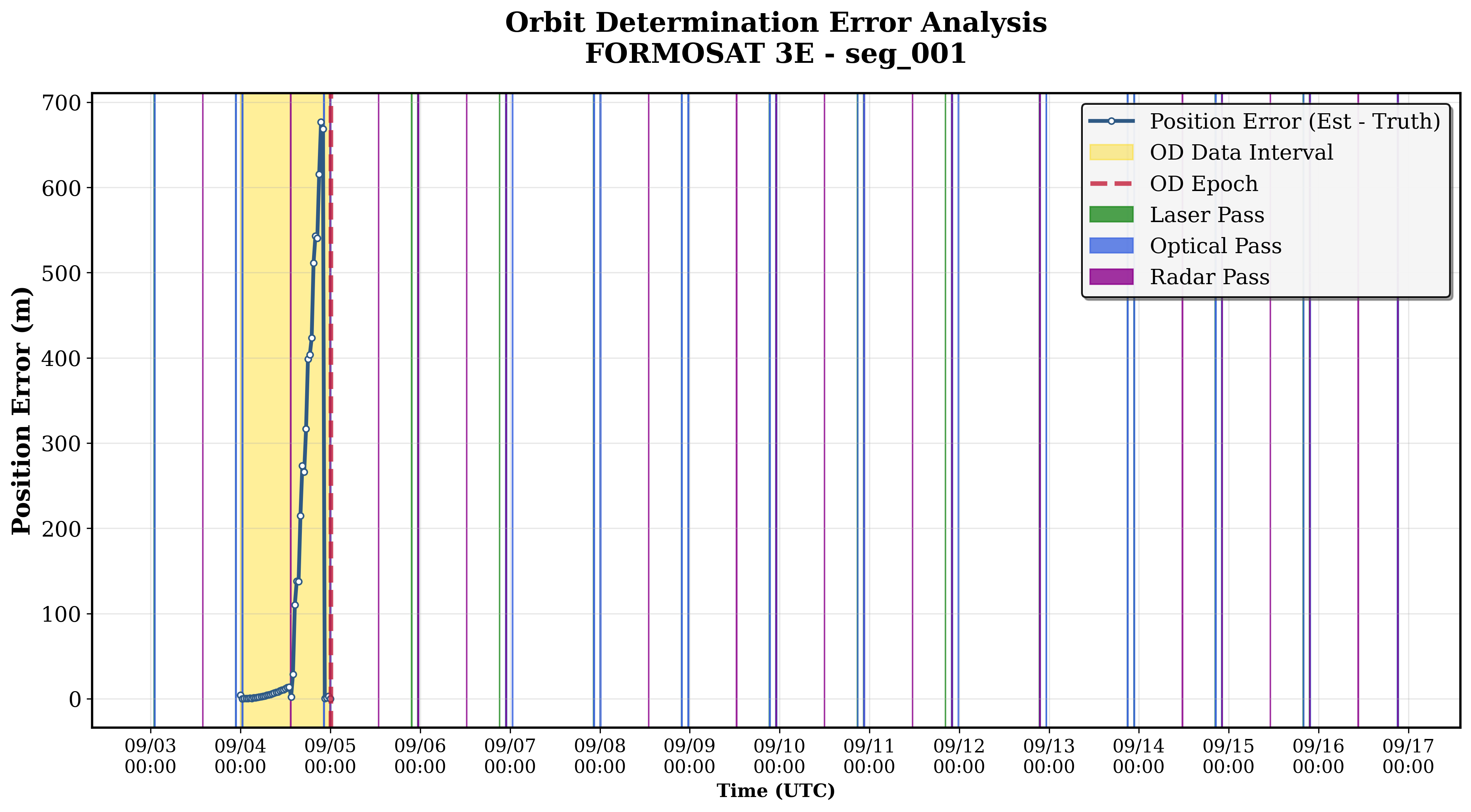
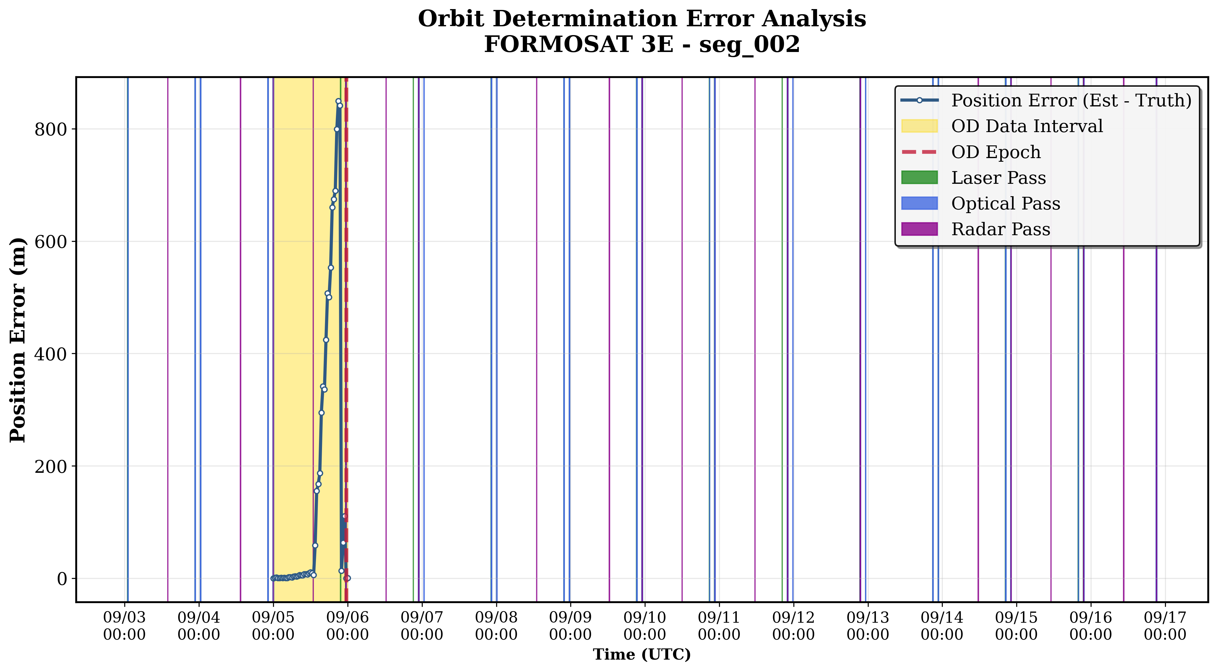
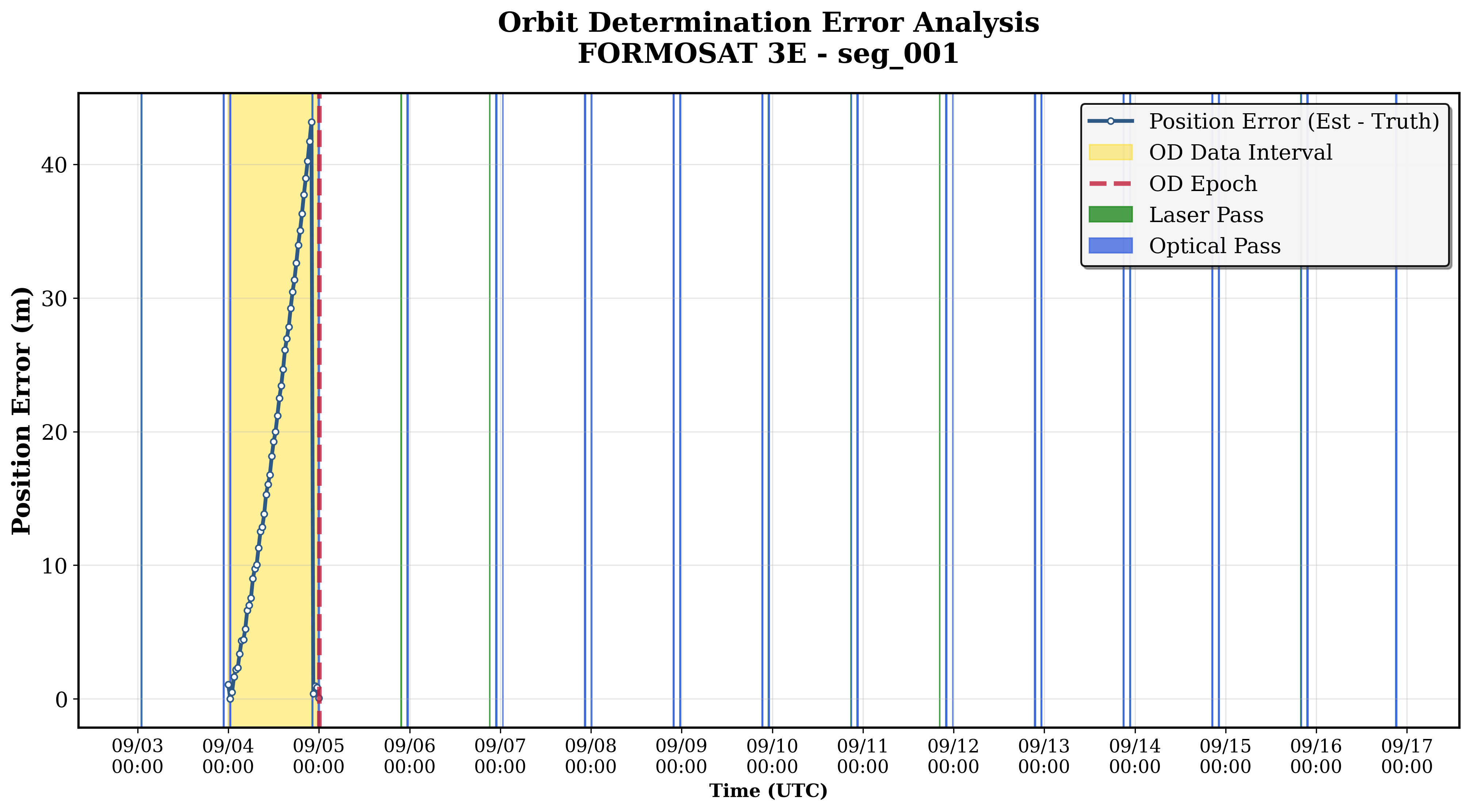
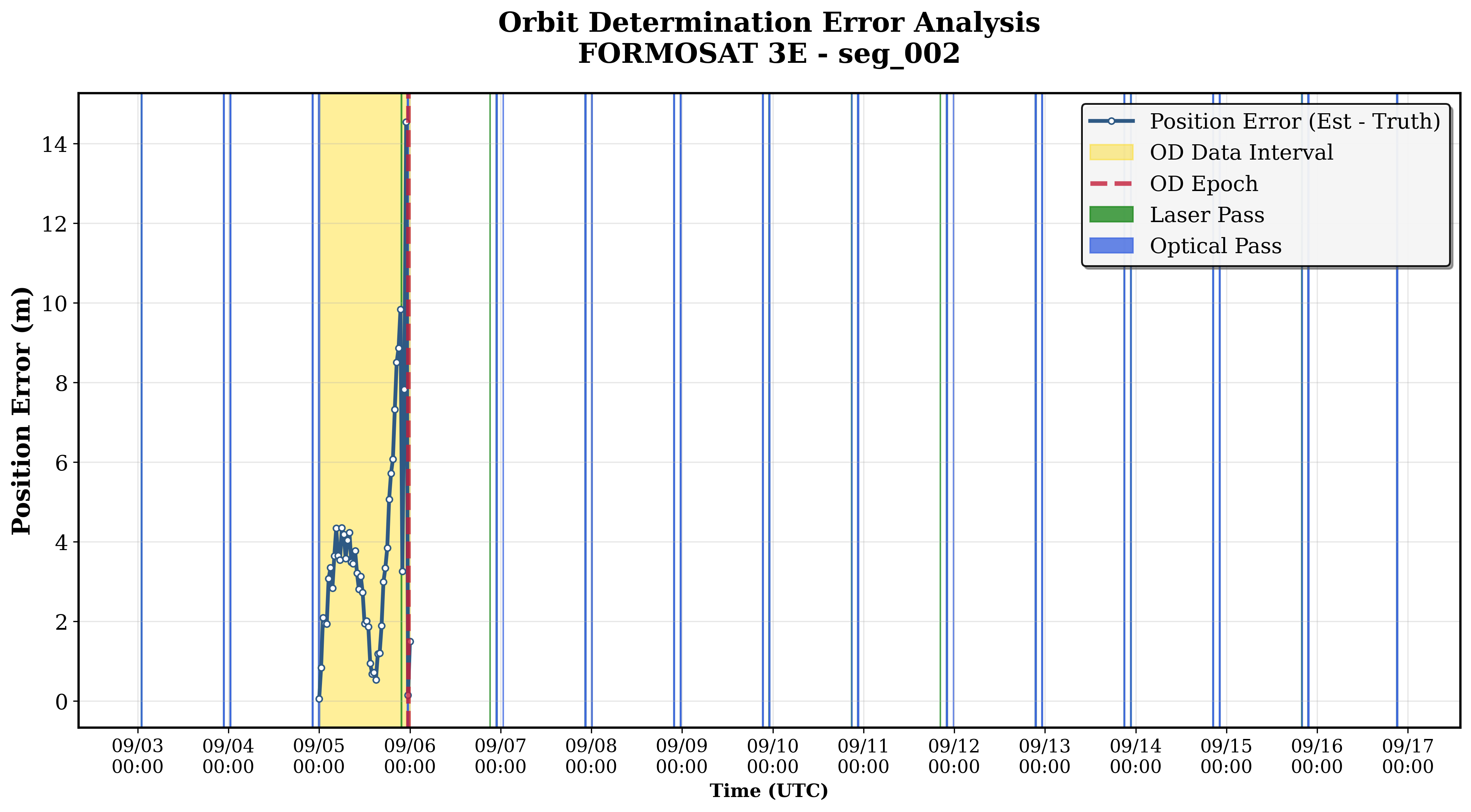
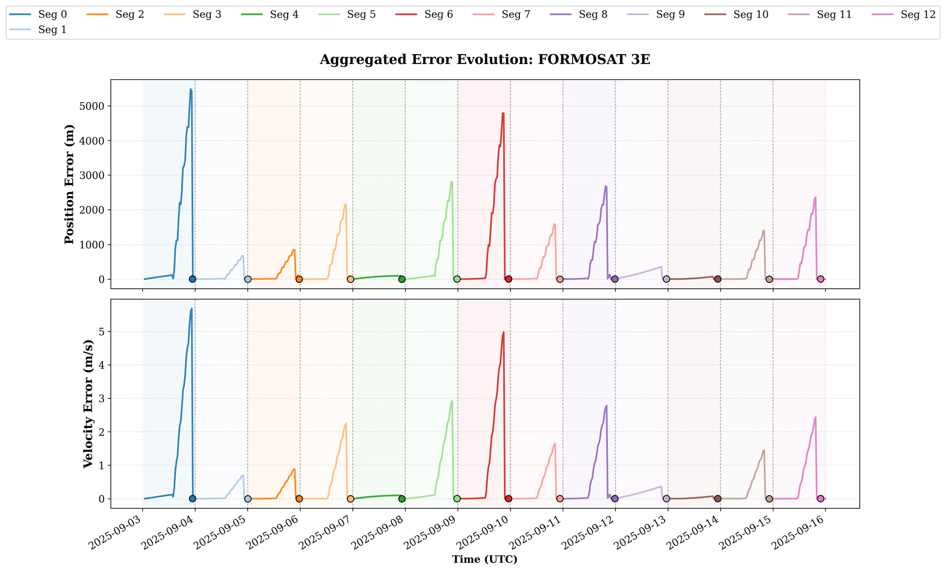
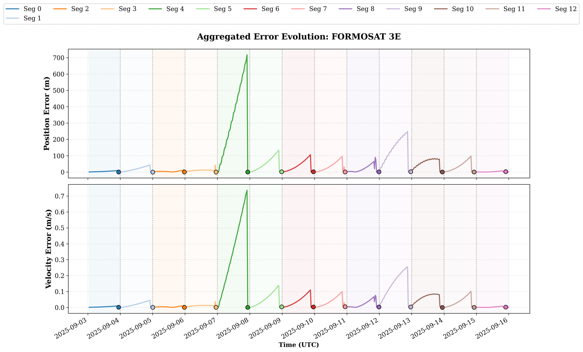
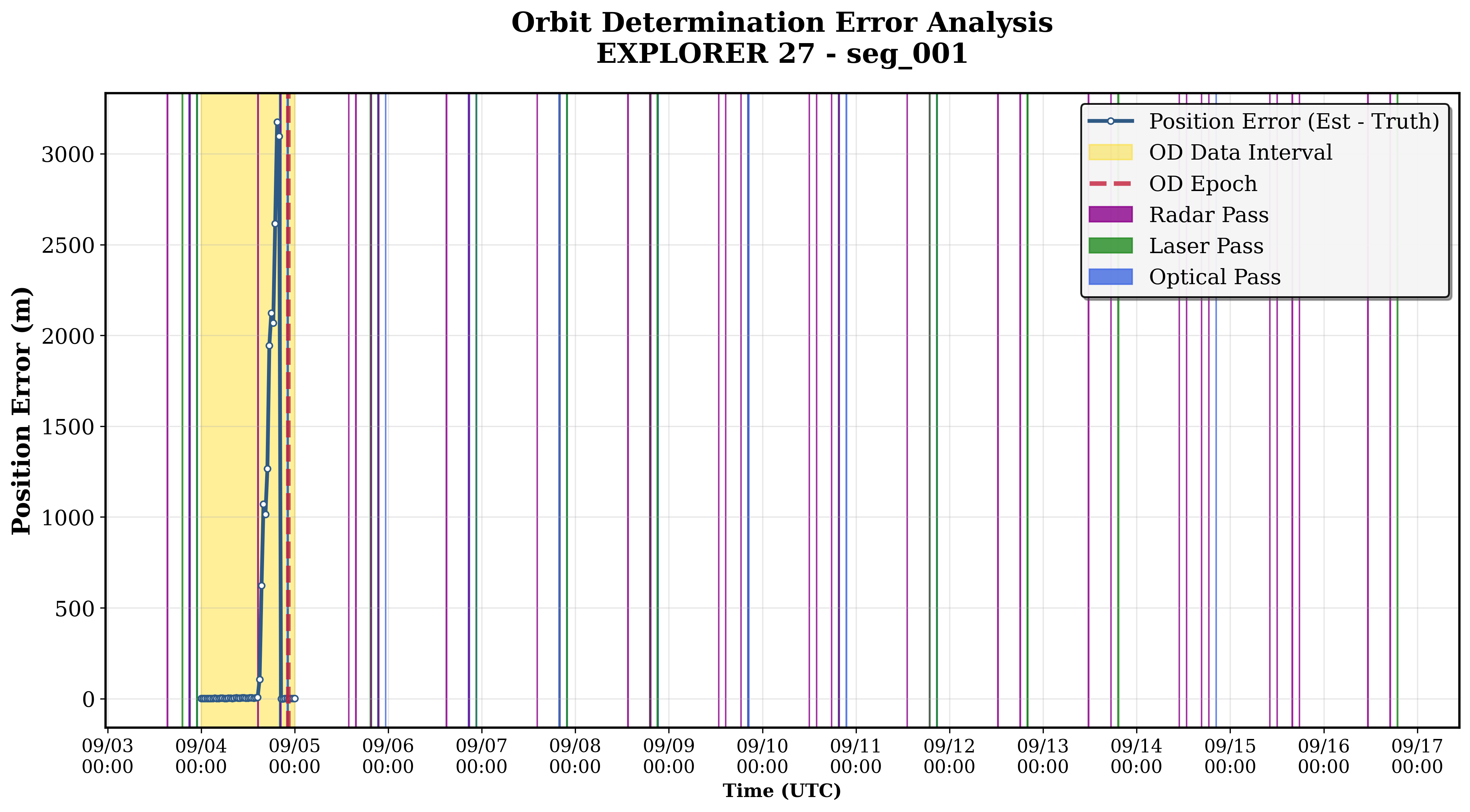
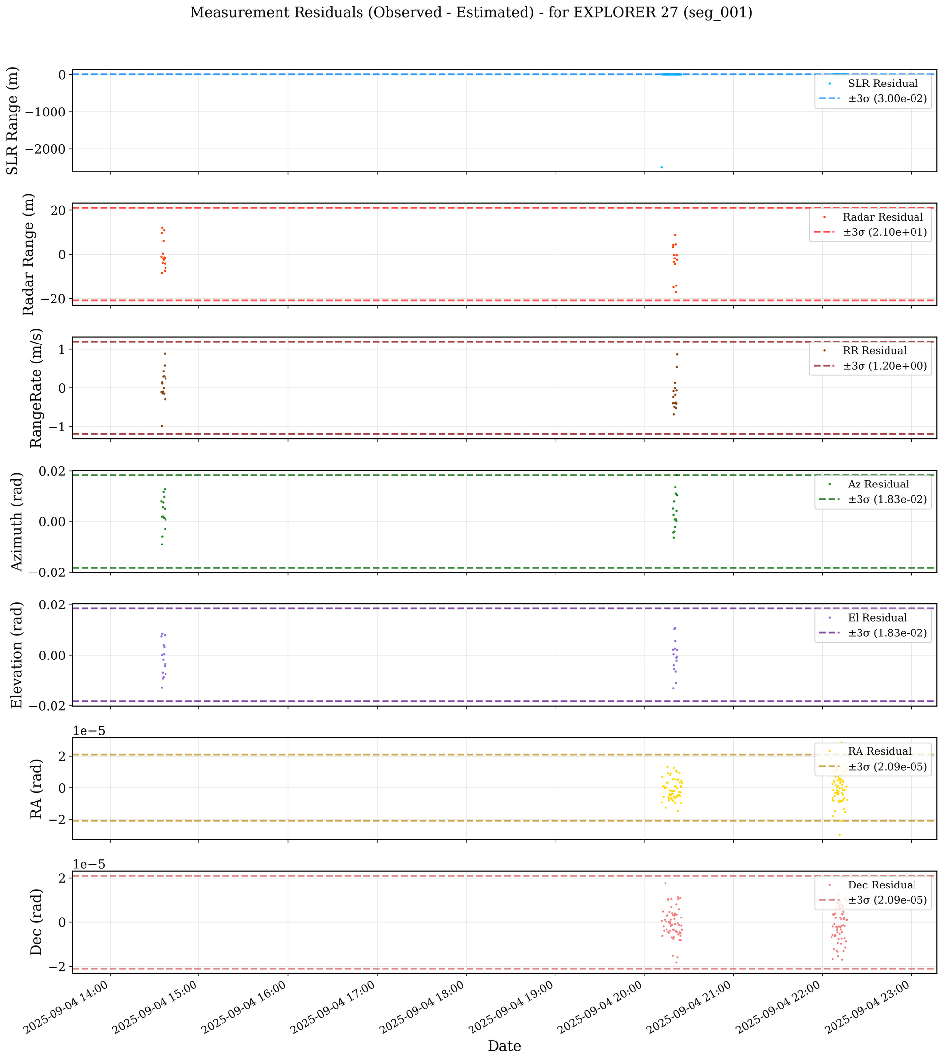
Now I understand what @markrutten said, thanks @Serrof. For example, here is an extensive analysis of the residuals (observed measurement vs estimated measurement by the UKF). The segment pass is the following one, with an initial error very small but with a divergence when the radar pass arrives.
Here you have the .csv format of the residuals. Sigma is the theoretical std of the sensor measurement (and as I am generating the measurements synthetically they are the “real” ones).
date,type,residual,sigma,sensor
2025-09-04T14:34:36.000000Z,RangeRate (m/s),-0.1082907577408605,0.4,radar_1
2025-09-04T14:34:36.000000Z,Radar Range (m),-1.0082419873215258,7.0,radar_1
2025-09-04T14:34:36.000000Z,Azimuth (rad),0.007931664812347528,0.006108652381980153,radar_1
2025-09-04T14:34:36.000000Z,Elevation (rad),0.007347732658462558,0.006108652381980153,radar_1
2025-09-04T14:34:48.000000Z,RangeRate (m/s),-0.9807599836429972,0.4,radar_1
2025-09-04T14:34:48.000000Z,Radar Range (m),9.553990427870303,7.0,radar_1
2025-09-04T14:34:48.000000Z,Azimuth (rad),0.0018095869866239234,0.006108652381980153,radar_1
2025-09-04T14:34:48.000000Z,Elevation (rad),-0.012929019011269638,0.006108652381980153,radar_1
2025-09-04T14:35:00.000000Z,RangeRate (m/s),0.1426324270933037,0.4,radar_1
2025-09-04T14:35:00.000000Z,Radar Range (m),-8.550006423611194,7.0,radar_1
2025-09-04T14:35:00.000000Z,Azimuth (rad),-0.009055427157117268,0.006108652381980153,radar_1
2025-09-04T14:35:00.000000Z,Elevation (rad),2.4899704233916076e-05,0.006108652381980153,radar_1
2025-09-04T14:35:12.000000Z,RangeRate (m/s),0.11119287428522284,0.4,radar_1
2025-09-04T14:35:12.000000Z,Radar Range (m),12.079194069374353,7.0,radar_1
2025-09-04T14:35:12.000000Z,Azimuth (rad),-0.005943504558033386,0.006108652381980153,radar_1
2025-09-04T14:35:12.000000Z,Elevation (rad),0.008309678996939018,0.006108652381980153,radar_1
2025-09-04T14:35:24.000000Z,RangeRate (m/s),-0.14346758578197694,0.4,radar_1
2025-09-04T14:35:24.000000Z,Radar Range (m),-3.851352021796629,7.0,radar_1
2025-09-04T14:35:24.000000Z,Azimuth (rad),0.002049971566658648,0.006108652381980153,radar_1
2025-09-04T14:35:24.000000Z,Elevation (rad),-0.00695770631426762,0.006108652381980153,radar_1
2025-09-04T14:35:36.000000Z,RangeRate (m/s),-0.09888481001135574,0.4,radar_1
2025-09-04T14:35:36.000000Z,Radar Range (m),0.37685335148125887,7.0,radar_1
2025-09-04T14:35:36.000000Z,Azimuth (rad),0.00571406898777127,0.006108652381980153,radar_1
2025-09-04T14:35:36.000000Z,Elevation (rad),-0.009260714322378516,0.006108652381980153,radar_1
2025-09-04T14:35:48.000000Z,RangeRate (m/s),0.290927522997265,0.4,radar_1
2025-09-04T14:35:48.000000Z,Radar Range (m),-2.0086936373263597,7.0,radar_1
2025-09-04T14:35:48.000000Z,Azimuth (rad),0.007497708640227252,0.006108652381980153,radar_1
2025-09-04T14:35:48.000000Z,Elevation (rad),-0.0019244057819666205,0.006108652381980153,radar_1
2025-09-04T14:36:00.000000Z,RangeRate (m/s),0.43075889498061315,0.4,radar_1
2025-09-04T14:36:00.000000Z,Radar Range (m),6.0673448361922055,7.0,radar_1
2025-09-04T14:36:00.000000Z,Azimuth (rad),0.011686193075571172,0.006108652381980153,radar_1
2025-09-04T14:36:00.000000Z,Elevation (rad),-0.00869350096989574,0.006108652381980153,radar_1
2025-09-04T14:36:12.000000Z,RangeRate (m/s),-0.000265203191929686,0.4,radar_1
2025-09-04T14:36:12.000000Z,Radar Range (m),-2.5729294908232987,7.0,radar_1
2025-09-04T14:36:12.000000Z,Azimuth (rad),0.0014758555304057452,0.006108652381980153,radar_1
2025-09-04T14:36:12.000000Z,Elevation (rad),0.003857425599235076,0.006108652381980153,radar_1
2025-09-04T14:36:24.000000Z,RangeRate (m/s),-0.14558745385875227,0.4,radar_1
2025-09-04T14:36:24.000000Z,Radar Range (m),10.774831479648128,7.0,radar_1
2025-09-04T14:36:24.000000Z,Azimuth (rad),0.00974312746966488,0.006108652381980153,radar_1
2025-09-04T14:36:24.000000Z,Elevation (rad),0.00042487054595896634,0.006108652381980153,radar_1
2025-09-04T14:36:36.000000Z,RangeRate (m/s),0.2970237087113219,0.4,radar_1
2025-09-04T14:36:36.000000Z,Radar Range (m),-1.3672216727863997,7.0,radar_1
2025-09-04T14:36:36.000000Z,Azimuth (rad),0.001184595693695556,0.006108652381980153,radar_1
2025-09-04T14:36:36.000000Z,Elevation (rad),0.003176338026302794,0.006108652381980153,radar_1
2025-09-04T14:36:48.000000Z,RangeRate (m/s),0.5831817415648857,0.4,radar_1
2025-09-04T14:36:48.000000Z,Radar Range (m),-7.594542928272858,7.0,radar_1
2025-09-04T14:36:48.000000Z,Azimuth (rad),0.012675225220667663,0.006108652381980153,radar_1
2025-09-04T14:36:48.000000Z,Elevation (rad),0.00783711502500184,0.006108652381980153,radar_1
2025-09-04T14:37:00.000000Z,RangeRate (m/s),0.8855998766994162,0.4,radar_1
2025-09-04T14:37:00.000000Z,Radar Range (m),-4.236021857243031,7.0,radar_1
2025-09-04T14:37:00.000000Z,Azimuth (rad),0.005082920039387595,0.006108652381980153,radar_1
2025-09-04T14:37:00.000000Z,Elevation (rad),-0.004445110604792579,0.006108652381980153,radar_1
2025-09-04T14:37:12.000000Z,RangeRate (m/s),-0.28788918164173083,0.4,radar_1
2025-09-04T14:37:12.000000Z,Radar Range (m),-1.629587716422975,7.0,radar_1
2025-09-04T14:37:12.000000Z,Azimuth (rad),-0.0030056214012335047,0.006108652381980153,radar_1
2025-09-04T14:37:12.000000Z,Elevation (rad),-0.0036799999874151945,0.006108652381980153,radar_1
2025-09-04T14:37:24.000000Z,RangeRate (m/s),0.24031196030045976,0.4,radar_1
2025-09-04T14:37:24.000000Z,Radar Range (m),-6.16312653128989,7.0,radar_1
2025-09-04T14:37:24.000000Z,Azimuth (rad),0.0007236883464973864,0.006108652381980153,radar_1
2025-09-04T14:37:24.000000Z,Elevation (rad),-0.007490312270591826,0.006108652381980153,radar_1
2025-09-04T20:11:40.000000Z,SLR Range (m),-2483.9848325536586,0.01,laser_1
2025-09-04T20:11:40.000000Z,RA (rad),-9.499474437735245e-06,6.981317007977318e-06,telescope_1
2025-09-04T20:11:40.000000Z,Dec (rad),4.5277562860102094e-07,6.981317007977318e-06,telescope_1
2025-09-04T20:12:05.000000Z,SLR Range (m),0.9822207852266729,0.01,laser_1
2025-09-04T20:12:05.000000Z,SLR Range (m),0.48967807414010167,0.01,laser_2
2025-09-04T20:12:05.000000Z,RA (rad),6.734011685161079e-06,6.981317007977318e-06,telescope_1
2025-09-04T20:12:05.000000Z,Dec (rad),-6.1417229021976105e-06,6.981317007977318e-06,telescope_1
2025-09-04T20:12:30.000000Z,SLR Range (m),0.10304525308310986,0.01,laser_1
2025-09-04T20:12:30.000000Z,SLR Range (m),-0.003875811118632555,0.01,laser_2
2025-09-04T20:12:30.000000Z,RA (rad),9.19556263578869e-07,6.981317007977318e-06,telescope_1
2025-09-04T20:12:30.000000Z,Dec (rad),4.877184793472544e-06,6.981317007977318e-06,telescope_1
2025-09-04T20:12:55.000000Z,SLR Range (m),-0.00674667302519083,0.01,laser_1
2025-09-04T20:12:55.000000Z,SLR Range (m),0.0019791037775576115,0.01,laser_2
2025-09-04T20:12:55.000000Z,RA (rad),-5.623214668570853e-06,6.981317007977318e-06,telescope_1
2025-09-04T20:12:55.000000Z,Dec (rad),-1.9586123635173536e-06,6.981317007977318e-06,telescope_1
2025-09-04T20:13:20.000000Z,SLR Range (m),0.04265895439311862,0.01,laser_1
2025-09-04T20:13:20.000000Z,SLR Range (m),-0.0007661227136850357,0.01,laser_2
2025-09-04T20:13:20.000000Z,RA (rad),6.275217434570379e-07,6.981317007977318e-06,telescope_1
2025-09-04T20:13:20.000000Z,Dec (rad),-3.7505920811309323e-06,6.981317007977318e-06,telescope_1
2025-09-04T20:13:45.000000Z,SLR Range (m),0.0012012859806418419,0.01,laser_1
2025-09-04T20:13:45.000000Z,SLR Range (m),-0.030977773014456034,0.01,laser_2
2025-09-04T20:13:45.000000Z,RA (rad),-4.3604230759441975e-07,6.981317007977318e-06,telescope_1
2025-09-04T20:13:45.000000Z,Dec (rad),1.0015582058153782e-06,6.981317007977318e-06,telescope_1
2025-09-04T20:14:10.000000Z,SLR Range (m),0.036250055534765124,0.01,laser_1
2025-09-04T20:14:10.000000Z,SLR Range (m),0.023701879661530256,0.01,laser_2
2025-09-04T20:14:10.000000Z,RA (rad),-1.7413977637659173e-07,6.981317007977318e-06,telescope_1
2025-09-04T20:14:10.000000Z,Dec (rad),1.7708584684972273e-05,6.981317007977318e-06,telescope_1
2025-09-04T20:14:35.000000Z,SLR Range (m),-0.02415871899574995,0.01,laser_1
2025-09-04T20:14:35.000000Z,SLR Range (m),0.013314144685864449,0.01,laser_2
2025-09-04T20:14:35.000000Z,RA (rad),-1.2822196945538877e-05,6.981317007977318e-06,telescope_1
2025-09-04T20:14:35.000000Z,Dec (rad),1.4471515541458757e-07,6.981317007977318e-06,telescope_1
2025-09-04T20:15:00.000000Z,SLR Range (m),-0.012925806688144803,0.01,laser_1
2025-09-04T20:15:00.000000Z,SLR Range (m),0.01719088153913617,0.01,laser_2
2025-09-04T20:15:00.000000Z,RA (rad),2.3458602882442392e-07,6.981317007977318e-06,telescope_1
2025-09-04T20:15:00.000000Z,Dec (rad),-3.2642613034816748e-06,6.981317007977318e-06,telescope_1
2025-09-04T20:15:25.000000Z,SLR Range (m),0.00902405777014792,0.01,laser_1
2025-09-04T20:15:25.000000Z,SLR Range (m),-0.02002347889356315,0.01,laser_2
2025-09-04T20:15:25.000000Z,RA (rad),3.2815744326342156e-06,6.981317007977318e-06,telescope_1
2025-09-04T20:15:25.000000Z,Dec (rad),3.021211289699899e-06,6.981317007977318e-06,telescope_1
2025-09-04T20:15:50.000000Z,SLR Range (m),-0.031707103131338954,0.01,laser_1
2025-09-04T20:15:50.000000Z,SLR Range (m),0.0349963316693902,0.01,laser_2
2025-09-04T20:15:50.000000Z,RA (rad),1.3348776492616565e-05,6.981317007977318e-06,telescope_1
2025-09-04T20:15:50.000000Z,Dec (rad),3.1471547686789947e-06,6.981317007977318e-06,telescope_1
2025-09-04T20:16:00.000000Z,RA (rad),3.057721392973889e-06,6.981317007977318e-06,telescope_3
2025-09-04T20:16:00.000000Z,Dec (rad),-4.26752447302281e-06,6.981317007977318e-06,telescope_3
2025-09-04T20:16:15.000000Z,SLR Range (m),-0.02167380042374134,0.01,laser_1
2025-09-04T20:16:15.000000Z,SLR Range (m),-0.01869438891299069,0.01,laser_2
2025-09-04T20:16:15.000000Z,RA (rad),9.35866152795839e-06,6.981317007977318e-06,telescope_1
2025-09-04T20:16:15.000000Z,Dec (rad),1.0104932530841104e-05,6.981317007977318e-06,telescope_1
2025-09-04T20:16:20.000000Z,RA (rad),-5.752724306695711e-06,6.981317007977318e-06,telescope_3
2025-09-04T20:16:20.000000Z,Dec (rad),1.0432623520517659e-05,6.981317007977318e-06,telescope_3
2025-09-04T20:16:40.000000Z,SLR Range (m),-0.016672587720677257,0.01,laser_1
2025-09-04T20:16:40.000000Z,RA (rad),-7.138110170057388e-06,6.981317007977318e-06,telescope_3
2025-09-04T20:16:40.000000Z,Dec (rad),-2.111714077768223e-07,6.981317007977318e-06,telescope_3
2025-09-04T20:16:40.000000Z,SLR Range (m),0.021470044972375035,0.01,laser_2
2025-09-04T20:16:40.000000Z,RA (rad),-7.972311555803913e-06,6.981317007977318e-06,telescope_1
2025-09-04T20:16:40.000000Z,Dec (rad),-4.799925233278657e-06,6.981317007977318e-06,telescope_1
2025-09-04T20:17:00.000000Z,RA (rad),-2.0858054317951513e-05,6.981317007977318e-06,telescope_3
2025-09-04T20:17:00.000000Z,Dec (rad),8.858611172390951e-08,6.981317007977318e-06,telescope_3
2025-09-04T20:17:05.000000Z,SLR Range (m),0.016517315758392215,0.01,laser_1
2025-09-04T20:17:05.000000Z,SLR Range (m),0.015257595805451274,0.01,laser_2
2025-09-04T20:17:05.000000Z,RA (rad),-3.866049765210988e-06,6.981317007977318e-06,telescope_1
2025-09-04T20:17:05.000000Z,Dec (rad),4.683965096452525e-06,6.981317007977318e-06,telescope_1
2025-09-04T20:17:20.000000Z,RA (rad),-1.5889082050080106e-06,6.981317007977318e-06,telescope_3
2025-09-04T20:17:20.000000Z,Dec (rad),7.628225195954741e-08,6.981317007977318e-06,telescope_3
2025-09-04T20:17:30.000000Z,SLR Range (m),0.03829953633248806,0.01,laser_1
2025-09-04T20:17:30.000000Z,SLR Range (m),0.024673533160239458,0.01,laser_2
2025-09-04T20:17:30.000000Z,RA (rad),7.979559184745355e-06,6.981317007977318e-06,telescope_1
2025-09-04T20:17:30.000000Z,Dec (rad),-3.830856185826903e-06,6.981317007977318e-06,telescope_1
2025-09-04T20:17:40.000000Z,RA (rad),-4.750562596189667e-06,6.981317007977318e-06,telescope_3
2025-09-04T20:17:40.000000Z,Dec (rad),-7.295202411328194e-07,6.981317007977318e-06,telescope_3
2025-09-04T20:17:55.000000Z,SLR Range (m),-0.00721596647053957,0.01,laser_1
2025-09-04T20:17:55.000000Z,SLR Range (m),0.0064556351862847805,0.01,laser_2
2025-09-04T20:17:55.000000Z,RA (rad),9.196192429339334e-06,6.981317007977318e-06,telescope_1
2025-09-04T20:17:55.000000Z,Dec (rad),-1.7609081814917715e-06,6.981317007977318e-06,telescope_1
2025-09-04T20:18:00.000000Z,RA (rad),-6.39101573507439e-06,6.981317007977318e-06,telescope_3
2025-09-04T20:18:00.000000Z,Dec (rad),1.044127702132247e-06,6.981317007977318e-06,telescope_3
2025-09-04T20:18:20.000000Z,SLR Range (m),0.005713354796171188,0.01,laser_1
2025-09-04T20:18:20.000000Z,RA (rad),-4.315380190966778e-06,6.981317007977318e-06,telescope_3
2025-09-04T20:18:20.000000Z,Dec (rad),1.0503238620118704e-05,6.981317007977318e-06,telescope_3
2025-09-04T20:18:20.000000Z,SLR Range (m),-0.0041564470157027245,0.01,laser_2
2025-09-04T20:18:20.000000Z,RA (rad),-1.8379773349952444e-06,6.981317007977318e-06,telescope_1
2025-09-04T20:18:20.000000Z,Dec (rad),6.839308349992912e-06,6.981317007977318e-06,telescope_1
2025-09-04T20:18:40.000000Z,RA (rad),-7.335926789142633e-06,6.981317007977318e-06,telescope_3
2025-09-04T20:18:40.000000Z,Dec (rad),-6.8720039323455495e-06,6.981317007977318e-06,telescope_3
2025-09-04T20:18:45.000000Z,SLR Range (m),-0.008908068295568228,0.01,laser_1
2025-09-04T20:18:45.000000Z,SLR Range (m),-0.023649074835702777,0.01,laser_2
2025-09-04T20:18:45.000000Z,RA (rad),-3.628251120213477e-06,6.981317007977318e-06,telescope_1
2025-09-04T20:18:45.000000Z,Dec (rad),-1.2907936134398668e-06,6.981317007977318e-06,telescope_1
2025-09-04T20:19:00.000000Z,RA (rad),-2.130815022649557e-06,6.981317007977318e-06,telescope_3
2025-09-04T20:19:00.000000Z,Dec (rad),4.115943565502489e-06,6.981317007977318e-06,telescope_3
2025-09-04T20:19:10.000000Z,SLR Range (m),0.014805451268330216,0.01,laser_1
2025-09-04T20:19:10.000000Z,SLR Range (m),0.0019812847021967173,0.01,laser_2
2025-09-04T20:19:10.000000Z,RA (rad),5.318895829775627e-06,6.981317007977318e-06,telescope_1
2025-09-04T20:19:10.000000Z,Dec (rad),-1.5245275206132725e-05,6.981317007977318e-06,telescope_1
2025-09-04T20:19:20.000000Z,RA (rad),-3.656478649416428e-06,6.981317007977318e-06,telescope_3
2025-09-04T20:19:20.000000Z,Dec (rad),3.401663676419475e-06,6.981317007977318e-06,telescope_3
2025-09-04T20:19:24.000000Z,RangeRate (m/s),-0.40535168309111214,0.4,radar_1
2025-09-04T20:19:24.000000Z,Radar Range (m),3.238938099006191,7.0,radar_1
2025-09-04T20:19:24.000000Z,Azimuth (rad),0.0051707427196912015,0.006108652381980153,radar_1
2025-09-04T20:19:24.000000Z,Elevation (rad),0.0020800080870257975,0.006108652381980153,radar_1
2025-09-04T20:19:35.000000Z,SLR Range (m),-0.005667946999892592,0.01,laser_1
2025-09-04T20:19:35.000000Z,SLR Range (m),0.002593471435829997,0.01,laser_2
2025-09-04T20:19:35.000000Z,RA (rad),-8.046234104108763e-06,6.981317007977318e-06,telescope_1
2025-09-04T20:19:35.000000Z,Dec (rad),-3.4297675930439198e-06,6.981317007977318e-06,telescope_1
2025-09-04T20:19:36.000000Z,RangeRate (m/s),-0.22756924055647687,0.4,radar_1
2025-09-04T20:19:36.000000Z,Radar Range (m),4.2426568765658885,7.0,radar_1
2025-09-04T20:19:36.000000Z,Azimuth (rad),-0.004311903453537269,0.006108652381980153,radar_1
2025-09-04T20:19:36.000000Z,Elevation (rad),-0.013123153391862985,0.006108652381980153,radar_1
2025-09-04T20:19:40.000000Z,RA (rad),-1.8344437018313897e-06,6.981317007977318e-06,telescope_3
2025-09-04T20:19:40.000000Z,Dec (rad),-7.404178932864103e-06,6.981317007977318e-06,telescope_3
2025-09-04T20:19:48.000000Z,RangeRate (m/s),-0.07971542584846247,0.4,radar_1
2025-09-04T20:19:48.000000Z,Radar Range (m),-14.948403078364208,7.0,radar_1
2025-09-04T20:19:48.000000Z,Azimuth (rad),0.0026463755379357856,0.006108652381980153,radar_1
2025-09-04T20:19:48.000000Z,Elevation (rad),0.00038061008176160094,0.006108652381980153,radar_1
2025-09-04T20:20:00.000000Z,RangeRate (m/s),-0.6833696614471592,0.4,radar_1
2025-09-04T20:20:00.000000Z,Radar Range (m),-3.4772068625316024,7.0,radar_1
2025-09-04T20:20:00.000000Z,Azimuth (rad),-0.006347502371357727,0.006108652381980153,radar_1
2025-09-04T20:20:00.000000Z,Elevation (rad),-0.004114666326170191,0.006108652381980153,radar_1
2025-09-04T20:20:00.000000Z,SLR Range (m),0.020459336694329977,0.01,laser_1
2025-09-04T20:20:00.000000Z,RA (rad),1.2700028496404059e-05,6.981317007977318e-06,telescope_3
2025-09-04T20:20:00.000000Z,Dec (rad),-3.496193304274031e-06,6.981317007977318e-06,telescope_3
2025-09-04T20:20:00.000000Z,SLR Range (m),0.027050355449318886,0.01,laser_2
2025-09-04T20:20:00.000000Z,RA (rad),-5.504877607753755e-06,6.981317007977318e-06,telescope_1
2025-09-04T20:20:00.000000Z,Dec (rad),-6.7145139596713754e-06,6.981317007977318e-06,telescope_1
2025-09-04T20:20:12.000000Z,RangeRate (m/s),-0.4012685725429037,0.4,radar_1
2025-09-04T20:20:12.000000Z,Radar Range (m),-0.201771869789809,7.0,radar_1
2025-09-04T20:20:12.000000Z,Azimuth (rad),0.007912470368688584,0.006108652381980153,radar_1
2025-09-04T20:20:12.000000Z,Elevation (rad),-0.00560383717402968,0.006108652381980153,radar_1
2025-09-04T20:20:20.000000Z,RA (rad),-2.031624457776715e-06,6.981317007977318e-06,telescope_3
2025-09-04T20:20:20.000000Z,Dec (rad),1.3915931287439287e-06,6.981317007977318e-06,telescope_3
2025-09-04T20:20:24.000000Z,RangeRate (m/s),-0.4929623953285045,0.4,radar_1
2025-09-04T20:20:24.000000Z,Radar Range (m),-1.8264938516076654,7.0,radar_1
2025-09-04T20:20:24.000000Z,Azimuth (rad),-0.0039899201456137234,0.006108652381980153,radar_1
2025-09-04T20:20:24.000000Z,Elevation (rad),0.010231862324253438,0.006108652381980153,radar_1
2025-09-04T20:20:25.000000Z,SLR Range (m),0.0031459445599466562,0.01,laser_1
2025-09-04T20:20:25.000000Z,SLR Range (m),-0.018497950630262494,0.01,laser_2
2025-09-04T20:20:25.000000Z,RA (rad),-6.6303789524324586e-06,6.981317007977318e-06,telescope_1
2025-09-04T20:20:25.000000Z,Dec (rad),3.012067871288604e-06,6.981317007977318e-06,telescope_1
2025-09-04T20:20:36.000000Z,RangeRate (m/s),-0.008086043810635601,0.4,radar_1
2025-09-04T20:20:36.000000Z,Radar Range (m),-4.493895949795842,7.0,radar_1
2025-09-04T20:20:36.000000Z,Azimuth (rad),0.0007514346987997911,0.006108652381980153,radar_1
2025-09-04T20:20:36.000000Z,Elevation (rad),0.002539353377251752,0.006108652381980153,radar_1
2025-09-04T20:20:40.000000Z,RA (rad),5.2022217191805e-06,6.981317007977318e-06,telescope_3
2025-09-04T20:20:40.000000Z,Dec (rad),4.046655740969074e-06,6.981317007977318e-06,telescope_3
2025-09-04T20:20:48.000000Z,RangeRate (m/s),0.1318795216898252,0.4,radar_1
2025-09-04T20:20:48.000000Z,Radar Range (m),-1.9086529165506363,7.0,radar_1
2025-09-04T20:20:48.000000Z,Azimuth (rad),-0.0022061605784391425,0.006108652381980153,radar_1
2025-09-04T20:20:48.000000Z,Elevation (rad),0.01081280289171671,0.006108652381980153,radar_1
2025-09-04T20:20:50.000000Z,SLR Range (m),0.004170918604359031,0.01,laser_1
2025-09-04T20:20:50.000000Z,SLR Range (m),-0.0029776415321975946,0.01,laser_2
2025-09-04T20:20:50.000000Z,RA (rad),8.632447068279703e-07,6.981317007977318e-06,telescope_1
2025-09-04T20:20:50.000000Z,Dec (rad),-8.438104949215486e-07,6.981317007977318e-06,telescope_1
2025-09-04T20:21:00.000000Z,RangeRate (m/s),-0.17296635668526505,0.4,radar_1
2025-09-04T20:21:00.000000Z,Radar Range (m),8.66512637026608,7.0,radar_1
2025-09-04T20:21:00.000000Z,Azimuth (rad),0.013571291621481851,0.006108652381980153,radar_1
2025-09-04T20:21:00.000000Z,Elevation (rad),0.00550120557493905,0.006108652381980153,radar_1
2025-09-04T20:21:00.000000Z,RA (rad),-9.746111297781468e-06,6.981317007977318e-06,telescope_3
2025-09-04T20:21:00.000000Z,Dec (rad),3.397884553654751e-06,6.981317007977318e-06,telescope_3
2025-09-04T20:21:12.000000Z,RangeRate (m/s),-0.38669002428332533,0.4,radar_1
2025-09-04T20:21:12.000000Z,Radar Range (m),4.450503569794819,7.0,radar_1
2025-09-04T20:21:12.000000Z,Azimuth (rad),0.010956167926829075,0.006108652381980153,radar_1
2025-09-04T20:21:12.000000Z,Elevation (rad),-0.006552902962603913,0.006108652381980153,radar_1
2025-09-04T20:21:15.000000Z,SLR Range (m),0.02068916312418878,0.01,laser_1
2025-09-04T20:21:15.000000Z,SLR Range (m),-0.00020818994380533695,0.01,laser_2
2025-09-04T20:21:15.000000Z,RA (rad),9.292477886058137e-07,6.981317007977318e-06,telescope_1
2025-09-04T20:21:15.000000Z,Dec (rad),-3.931103062487784e-06,6.981317007977318e-06,telescope_1
2025-09-04T20:21:20.000000Z,RA (rad),1.0947285465245926e-05,6.981317007977318e-06,telescope_3
2025-09-04T20:21:20.000000Z,Dec (rad),3.4295551268326285e-06,6.981317007977318e-06,telescope_3
2025-09-04T20:21:24.000000Z,RangeRate (m/s),-0.5243646343715227,0.4,radar_1
2025-09-04T20:21:24.000000Z,Radar Range (m),-17.164216538192704,7.0,radar_1
2025-09-04T20:21:24.000000Z,Azimuth (rad),0.0007542485099238938,0.006108652381980153,radar_1
2025-09-04T20:21:24.000000Z,Elevation (rad),-0.011038046495422393,0.006108652381980153,radar_1
2025-09-04T20:21:36.000000Z,RangeRate (m/s),-0.41612231177487047,0.4,radar_1
2025-09-04T20:21:36.000000Z,Radar Range (m),-14.18918255274184,7.0,radar_1
2025-09-04T20:21:36.000000Z,Azimuth (rad),0.00022227153974840874,0.006108652381980153,radar_1
2025-09-04T20:21:36.000000Z,Elevation (rad),-0.0009588980036367989,0.006108652381980153,radar_1
2025-09-04T20:21:40.000000Z,SLR Range (m),0.01770299836061895,0.01,laser_1
2025-09-04T20:21:40.000000Z,RA (rad),-5.426669939412321e-06,6.981317007977318e-06,telescope_3
2025-09-04T20:21:40.000000Z,Dec (rad),-1.822761941330797e-05,6.981317007977318e-06,telescope_3
2025-09-04T20:21:40.000000Z,SLR Range (m),-0.020582338329404593,0.01,laser_2
2025-09-04T20:21:40.000000Z,RA (rad),-6.075209702971485e-06,6.981317007977318e-06,telescope_1
2025-09-04T20:21:40.000000Z,Dec (rad),8.029832382405733e-06,6.981317007977318e-06,telescope_1
2025-09-04T20:21:48.000000Z,RangeRate (m/s),-0.06599474450194975,0.4,radar_1
2025-09-04T20:21:48.000000Z,Radar Range (m),-0.36044229567050934,7.0,radar_1
2025-09-04T20:21:48.000000Z,Azimuth (rad),0.004233130496177573,0.006108652381980153,radar_1
2025-09-04T20:21:48.000000Z,Elevation (rad),-0.002385132113140065,0.006108652381980153,radar_1
2025-09-04T20:22:00.000000Z,RangeRate (m/s),0.5441127872363722,0.4,radar_1
2025-09-04T20:22:00.000000Z,Radar Range (m),-0.2806427280884236,7.0,radar_1
2025-09-04T20:22:00.000000Z,Azimuth (rad),0.01835285823881927,0.006108652381980153,radar_1
2025-09-04T20:22:00.000000Z,Elevation (rad),-0.0005364987939400212,0.006108652381980153,radar_1
2025-09-04T20:22:00.000000Z,RA (rad),-3.3150341705034947e-07,6.981317007977318e-06,telescope_3
2025-09-04T20:22:00.000000Z,Dec (rad),3.521695868230479e-06,6.981317007977318e-06,telescope_3
2025-09-04T20:22:05.000000Z,SLR Range (m),-0.004589744843542576,0.01,laser_1
2025-09-04T20:22:05.000000Z,SLR Range (m),-9.612878784537315e-06,0.01,laser_2
2025-09-04T20:22:05.000000Z,RA (rad),1.0188479600214961e-05,6.981317007977318e-06,telescope_1
2025-09-04T20:22:05.000000Z,Dec (rad),-4.435767486016262e-06,6.981317007977318e-06,telescope_1
2025-09-04T20:22:12.000000Z,RangeRate (m/s),0.8647268871663982,0.4,radar_1
2025-09-04T20:22:12.000000Z,Radar Range (m),-2.5724699371494353,7.0,radar_1
2025-09-04T20:22:12.000000Z,Azimuth (rad),0.010403696991080569,0.006108652381980153,radar_1
2025-09-04T20:22:12.000000Z,Elevation (rad),0.0020371420060235623,0.006108652381980153,radar_1
2025-09-04T20:22:20.000000Z,RA (rad),4.847530872487127e-06,6.981317007977318e-06,telescope_3
2025-09-04T20:22:20.000000Z,Dec (rad),-1.584191183220951e-05,6.981317007977318e-06,telescope_3
2025-09-04T20:22:30.000000Z,SLR Range (m),-0.00038137147203087807,0.01,laser_1
2025-09-04T20:22:30.000000Z,SLR Range (m),0.00971421948634088,0.01,laser_2
2025-09-04T20:22:30.000000Z,RA (rad),-5.142788082612704e-06,6.981317007977318e-06,telescope_1
2025-09-04T20:22:30.000000Z,Dec (rad),-5.288038679163165e-07,6.981317007977318e-06,telescope_1
2025-09-04T20:22:40.000000Z,RA (rad),-1.4813044949879561e-05,6.981317007977318e-06,telescope_3
2025-09-04T20:22:40.000000Z,Dec (rad),1.127596689051713e-05,6.981317007977318e-06,telescope_3
2025-09-04T20:22:55.000000Z,SLR Range (m),-0.0037700177635997534,0.01,laser_1
2025-09-04T20:22:55.000000Z,SLR Range (m),-0.02353095216676593,0.01,laser_2
2025-09-04T20:22:55.000000Z,RA (rad),5.172703529954248e-06,6.981317007977318e-06,telescope_1
2025-09-04T20:22:55.000000Z,Dec (rad),1.026398447988644e-05,6.981317007977318e-06,telescope_1
2025-09-04T20:23:00.000000Z,RA (rad),-4.6589483126968645e-06,6.981317007977318e-06,telescope_3
2025-09-04T20:23:00.000000Z,Dec (rad),-5.511574400152153e-06,6.981317007977318e-06,telescope_3
2025-09-04T20:23:20.000000Z,SLR Range (m),-0.004299985710531473,0.01,laser_1
2025-09-04T20:23:20.000000Z,RA (rad),-4.488381298517474e-06,6.981317007977318e-06,telescope_3
2025-09-04T20:23:20.000000Z,Dec (rad),5.843777458103272e-06,6.981317007977318e-06,telescope_3
2025-09-04T20:23:20.000000Z,SLR Range (m),0.01046972069889307,0.01,laser_2
2025-09-04T20:23:20.000000Z,RA (rad),-2.7025555239812427e-06,6.981317007977318e-06,telescope_1
2025-09-04T20:23:20.000000Z,Dec (rad),-1.2829595817734352e-06,6.981317007977318e-06,telescope_1
2025-09-04T20:23:40.000000Z,RA (rad),9.011623058774454e-06,6.981317007977318e-06,telescope_3
2025-09-04T20:23:40.000000Z,Dec (rad),-5.009968900238082e-06,6.981317007977318e-06,telescope_3
2025-09-04T20:23:45.000000Z,SLR Range (m),0.0031909975223243237,0.01,laser_1
2025-09-04T20:23:45.000000Z,SLR Range (m),-0.02291649766266346,0.01,laser_2
2025-09-04T20:23:45.000000Z,RA (rad),9.348563267619348e-06,6.981317007977318e-06,telescope_1
2025-09-04T20:23:45.000000Z,Dec (rad),-7.954466755610845e-06,6.981317007977318e-06,telescope_1
2025-09-04T20:24:00.000000Z,RA (rad),3.1876489151594356e-06,6.981317007977318e-06,telescope_3
2025-09-04T20:24:00.000000Z,Dec (rad),-4.529600479086238e-06,6.981317007977318e-06,telescope_3
2025-09-04T20:24:10.000000Z,SLR Range (m),0.003502293024212122,0.01,laser_1
2025-09-04T20:24:10.000000Z,SLR Range (m),0.03308348311111331,0.01,laser_2
2025-09-04T20:24:10.000000Z,RA (rad),-5.165346435132001e-06,6.981317007977318e-06,telescope_1
2025-09-04T20:24:10.000000Z,Dec (rad),1.0815877864181478e-05,6.981317007977318e-06,telescope_1
2025-09-04T20:24:20.000000Z,RA (rad),-2.815716237059007e-06,6.981317007977318e-06,telescope_3
2025-09-04T20:24:20.000000Z,Dec (rad),-6.090272035630395e-06,6.981317007977318e-06,telescope_3
2025-09-04T20:24:35.000000Z,SLR Range (m),0.0015777763910591602,0.01,laser_1
2025-09-04T20:24:35.000000Z,SLR Range (m),-0.004817424342036247,0.01,laser_2
2025-09-04T20:24:35.000000Z,RA (rad),1.1714479531965694e-06,6.981317007977318e-06,telescope_1
2025-09-04T20:24:35.000000Z,Dec (rad),-5.039334794232353e-06,6.981317007977318e-06,telescope_1
2025-09-04T20:24:40.000000Z,RA (rad),-9.7492240016539e-06,6.981317007977318e-06,telescope_3
2025-09-04T20:24:40.000000Z,Dec (rad),-8.135074592297009e-06,6.981317007977318e-06,telescope_3
2025-09-04T20:25:00.000000Z,SLR Range (m),-0.0009901374578475952,0.01,laser_1
2025-09-04T20:25:00.000000Z,RA (rad),1.9818570251572964e-07,6.981317007977318e-06,telescope_3
2025-09-04T20:25:00.000000Z,Dec (rad),2.1164179571098174e-06,6.981317007977318e-06,telescope_3
2025-09-04T20:25:00.000000Z,SLR Range (m),0.018011906649917364,0.01,laser_2
2025-09-04T20:25:00.000000Z,RA (rad),4.354636938208589e-06,6.981317007977318e-06,telescope_1
2025-09-04T20:25:00.000000Z,Dec (rad),-1.5402287116828006e-06,6.981317007977318e-06,telescope_1
2025-09-04T20:25:20.000000Z,RA (rad),3.139312610811462e-06,6.981317007977318e-06,telescope_3
2025-09-04T20:25:20.000000Z,Dec (rad),-3.4205324516145552e-06,6.981317007977318e-06,telescope_3
2025-09-04T22:06:15.000000Z,SLR Range (m),-0.783302656840533,0.01,laser_1
2025-09-04T22:06:15.000000Z,RA (rad),1.827744635551909e-05,6.981317007977318e-06,telescope_1
2025-09-04T22:06:15.000000Z,Dec (rad),-6.776056094198735e-06,6.981317007977318e-06,telescope_1
2025-09-04T22:06:40.000000Z,SLR Range (m),0.005704654846340418,0.01,laser_1
2025-09-04T22:06:40.000000Z,RA (rad),2.4786689589717525e-06,6.981317007977318e-06,telescope_1
2025-09-04T22:06:40.000000Z,Dec (rad),-5.736969130309966e-06,6.981317007977318e-06,telescope_1
2025-09-04T22:07:00.000000Z,RA (rad),-6.194136082271484e-06,9.697049324080494e-06,telescope_2
2025-09-04T22:07:00.000000Z,Dec (rad),-1.662475449948353e-05,9.697049324080494e-06,telescope_2
2025-09-04T22:07:05.000000Z,SLR Range (m),-0.014550861436873674,0.01,laser_1
2025-09-04T22:07:05.000000Z,RA (rad),-7.727490951126015e-06,6.981317007977318e-06,telescope_1
2025-09-04T22:07:05.000000Z,Dec (rad),-1.903152446608436e-06,6.981317007977318e-06,telescope_1
2025-09-04T22:07:20.000000Z,RA (rad),-1.793655402604344e-05,9.697049324080494e-06,telescope_2
2025-09-04T22:07:20.000000Z,Dec (rad),3.6468051602955853e-06,9.697049324080494e-06,telescope_2
2025-09-04T22:07:30.000000Z,SLR Range (m),-0.014407176990061998,0.01,laser_1
2025-09-04T22:07:30.000000Z,SLR Range (m),0.029282893054187298,0.01,laser_2
2025-09-04T22:07:30.000000Z,RA (rad),-1.4273201225378784e-06,6.981317007977318e-06,telescope_1
2025-09-04T22:07:30.000000Z,Dec (rad),3.594180776028688e-06,6.981317007977318e-06,telescope_1
2025-09-04T22:07:40.000000Z,RA (rad),-8.232845801092736e-06,9.697049324080494e-06,telescope_2
2025-09-04T22:07:40.000000Z,Dec (rad),1.0414316544027358e-05,9.697049324080494e-06,telescope_2
2025-09-04T22:07:55.000000Z,SLR Range (m),0.012225708924233913,0.01,laser_1
2025-09-04T22:07:55.000000Z,SLR Range (m),-0.0016463049687445164,0.01,laser_2
2025-09-04T22:07:55.000000Z,RA (rad),4.377489186246919e-06,6.981317007977318e-06,telescope_1
2025-09-04T22:07:55.000000Z,Dec (rad),-1.2187295046456326e-05,6.981317007977318e-06,telescope_1
2025-09-04T22:08:00.000000Z,RA (rad),9.920396556672983e-06,9.697049324080494e-06,telescope_2
2025-09-04T22:08:00.000000Z,Dec (rad),3.4787013647452625e-06,9.697049324080494e-06,telescope_2
2025-09-04T22:08:20.000000Z,SLR Range (m),0.006032266654074192,0.01,laser_1
2025-09-04T22:08:20.000000Z,SLR Range (m),-0.003442504908889532,0.01,laser_2
2025-09-04T22:08:20.000000Z,RA (rad),3.283657887820368e-06,9.697049324080494e-06,telescope_2
2025-09-04T22:08:20.000000Z,Dec (rad),-6.127153029278354e-06,9.697049324080494e-06,telescope_2
2025-09-04T22:08:20.000000Z,RA (rad),-5.168957162737797e-06,6.981317007977318e-06,telescope_1
2025-09-04T22:08:20.000000Z,Dec (rad),-8.802047559430815e-07,6.981317007977318e-06,telescope_1
2025-09-04T22:08:40.000000Z,RA (rad),-1.4902806500183274e-05,9.697049324080494e-06,telescope_2
2025-09-04T22:08:40.000000Z,Dec (rad),-5.713878177049381e-06,9.697049324080494e-06,telescope_2
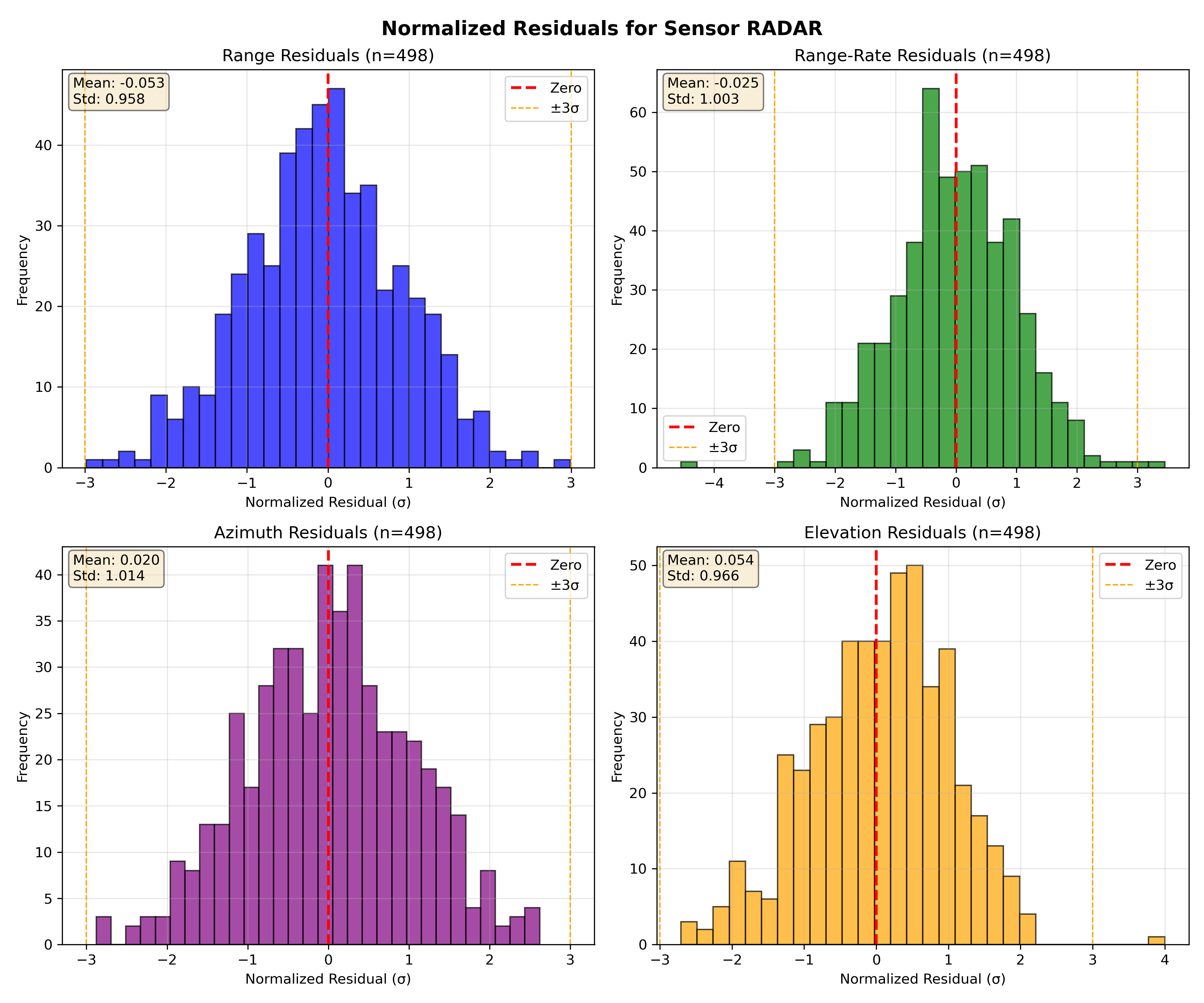
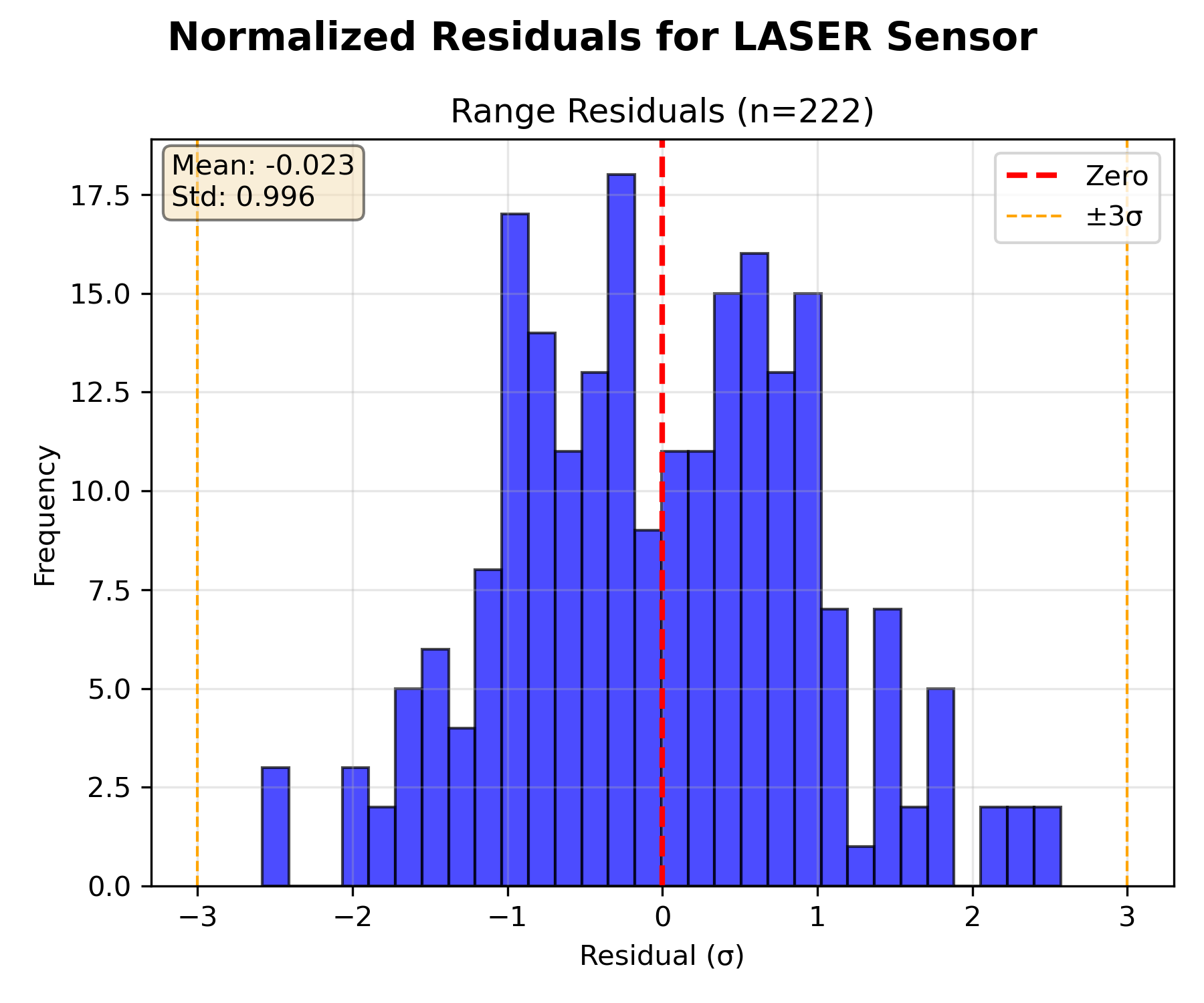
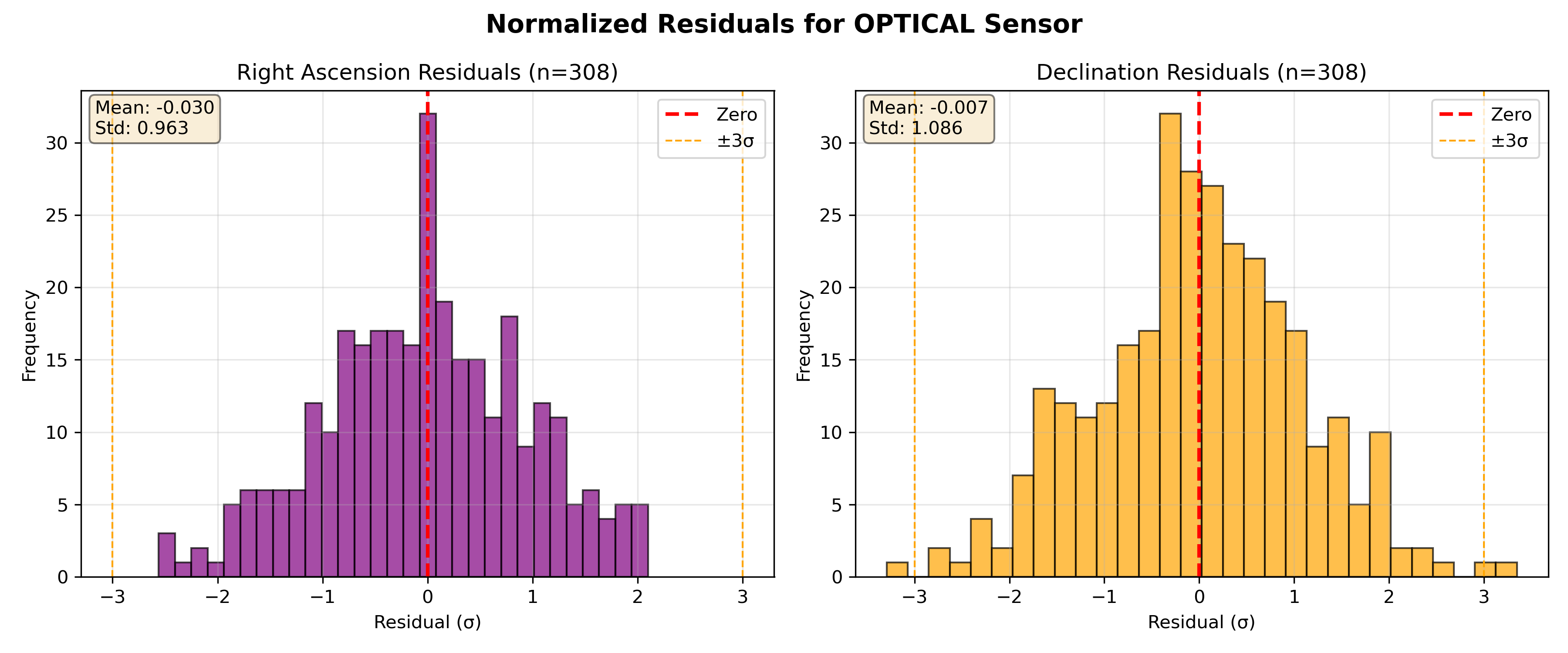
Finally, here I show an image of the residuals plotted for each type of measurement between the expected 3\sigma band for each kind of measurement.
As it can be seen the residuals are within the expected values (apart from that outlier of the laser).
Hope this helps. I have MANY MORE of these analyses. If you need more things just ask me and I’ll be happy to share if that helps to diagnose the malfunctioning. Thank you so much in advance.
Pd. Hope this is what you were asking for. If not, please tell me what you meant.