Edit: I’m stupid and was being blind, got it figured out. Not sure how to delete this post but admins feel free to do so
I am trying to get line-of-sight windows for a ground station on a highly inclined orbit using an ElevationDetector, but the date timestamps it was giving were pretty far off (or non-existent) compared to two other sources that agreed. I am doing a propagation with a simple Keplerian Orbit.
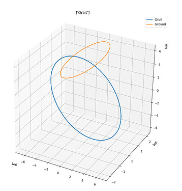
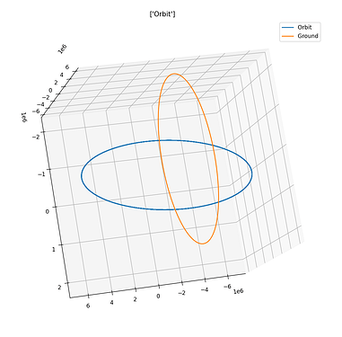
I narrowed the problem down to my ground station, but I’m not exactly sure what is wrong with it. When I plot the station’s location in ECI over 24 hours I get a strangely elongated ellipse, much more than I would expect. The ground station’s location is orange and the orbit is in blue. Here are two views for perspective:
Hopefully that’s clear, I can post another view in the comments if needed. The ground plot is a horizontal ellipse while the orbit is near vertical.
Here is my code to define the earth and ground station:
    earthConventions = IERSConventions.IERS_2010
    earthRadius      = Constants.WGS84_EARTH_EQUATORIAL_RADIUS
    earthFlattening  = Constants.WGS84_EARTH_FLATTENING
    earthBodyFrame   = FramesFactory.getITRF(earthConventions, False)
    earthShape = OneAxisEllipsoid(earthRadius, earthFlattening, earthBodyFrame)
    earthShape = ReferenceEllipsoid.getWgs84(earthBodyFrame)
    earthMu    = Constants.WGS84_EARTH_MU
    gravity_provider = GravityFieldFactory.getNormalizedProvider(175, 175)
    gravity_model = HolmesFeatherstoneAttractionModel(earthBodyFrame, gravity_provider)
    from org.orekit.frames import TopocentricFrame
    from org.orekit.bodies import GeodeticPoint
    from org.orekit.estimation.measurements import GroundStation
    earthShape = earthparameters['earthShape']
    coordinates    = GeodeticPoint(radians(latitude), radians(longitude), altitude)
    ground_frame   = TopocentricFrame(earthShape, coordinates, 'Barrow')
    ground_station = GroundStation(ground_frame)
    ground = {
        'station': ground_station,
        'frame': ground_frame
    }
And to convert the ground station coordinates for plotting I loop through the relevant times (every ~1 min for 24 hours) and call ground_frame.getPVCoordinates(date, FramesFactory.getGCRF())
I’m pretty lost about what the issue might be. Maybe I need a fresh set of eyes but I think the setup matches closely with given example code. Any tips would be greatly appreciated ![]()

