Hi,
I’m trying to use FootprintOverlapDetector detecting some region, but when I tried this region, I had a problem. The calculation time is very, very long. Finally, there is no calculation result and no error information. Is there something wrong with my use? I’ve tested other regions and the calculation results are normal.
Could you please tell me if my approach is correct or if there is any other way to detecte areas in Orekit?
Thanks a lot!
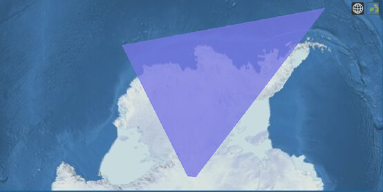
target = POLYGON((-64.53338282873283 -58.63979294971378,-131.7619986081599 -69.64071417850397,-131.7619986081599 -89.0,-64.53338282873283 -89.0,-64.53338282873283 -58.63979294971378))
propagator.setAttitudeProvider(new NadirPointing(FramesFactory.EME2000, PropService.earth));
final org.orekit.propagation.events.FieldOfView fov = new FieldOfView(Vector3D.PLUS_K,
Vector3D.PLUS_I, FastMath.toRadians(60 / 2.0),
Vector3D.PLUS_J, FastMath.toRadians(0.001d),
0.01d);
final FootprintOverlapDetector detector = new FootprintOverlapDetector(fov, earth, target, 30000.0).
withMaxCheck(5.0d).
withThreshold(1.0e-6d).
withHandler(new ContinueOnEvent());
final EventsLogger logger = new EventsLogger();
propagator.addEventDetector(logger.monitorDetector(detector));
propagator.propagate(start, end);
I suppose your coordinates are given as pairs with first component being longitude in degrees and second component being latitude in degrees? BEware that Orekit works with S.I. units only, i.e. it expactes angles in radians, not degrees. Also the Geodetic points constructors use latitude as first component and longitude as second component, your should check how your POLYGON method maps this. There is one classical glitch in spherical polygons that must be given in trigonometric (i.e. counterclockwise) directions, which means when you walk the border you should have the interior of the polygon on your left hand side and the exterior on your right hand side, but this seems to be correct in your list.
Also as your region is close to south pole and as FootprintOverlapDetector detects then the sub-satellite point enters/leaves the area of interest, this region can be seen only by satellites having at least 64.533 degrees inclination (and those at this inclination will only fly over the northest boundary of the area, between the forst two points).
I guess ther is a problem with degrees versus radians units.
Hi luc,
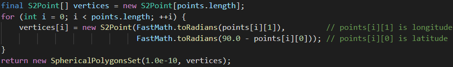
Thank you very much for your suggestions, I’ve checked how my POLYGON method maps the Geodetic points constructors, I think this is my problem. And when I refer to the region construct in FootprintOverlapDetectorTest like