Hi everyone,
I’m trying to applicate switching conditions between sun pointing law and target Pointing law (TargetPointing)
The trigger is an elevation detector (Basically to detect a ground station visibility).
I’m then getting the OEM and AEM file (created with the handler, using CIC format) in order to put it back in VTS (3D visualization).
It worked well and I’m able to see the transition between sun pointing and Target pointing.
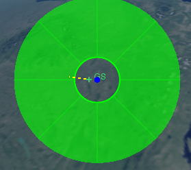
However, When the elevation is quite high, I can see a Discrepency between the targeted point and the true target point calculated by Orekit. So it miss the target (reasonably) as you can see in this picture.
I used of course the same frame in Orekit and VTS (EME 2000).
Here is my code :
ra = 500 * 1000.0  # Apogee in meters
rp = 500 * 1000.0  # Perigee in meters
# if SSO_Choice != 1, please indicate the orbit inclination, in degrees
i = 80  # Inclination in deg
omega = float(0)  # Perigee argument in deg
raan = float(0)  # Right ascension of ascending node in deg
lv = float(0)  # True anomaly in deg

a = (rp + ra + 2 * Constants.WGS84_EARTH_EQUATORIAL_RADIUS) / 2.0  # SMA
e = 1.0 - (rp + Constants.WGS84_EARTH_EQUATORIAL_RADIUS) / a  # Ecc

if SSO_Choice == 1:
    i = SSO_inclination_calculations(a,e)

# Satellite definition
satellite_mass = float(1.1)
area = float(0.015)

gs = GroundPoint("GS", latitude=45, longitude=20, altitude=10.0)

minimum_detectable_elev = 5.0

# ##################### END OF USER INPUTS #####################################
# ##############################################################################

propagator = PropagatorFactory.from_keplerian(
    a, e, i, omega, raan, lv, satellite_mass, area, initial_date
)

Elevation_Detector = Elevation_detector_wrapper(
    gs.topocentric, minimum_detectable_elev
)
Elevation_Detector.add_event_detectors_to_propagator(propagator)


sun = CelestialBodyFactory.getSun()
Sun_Pointing_law=CelestialBodyPointed(propagator.getFrame(), sun, Vector3D.MINUS_I, Vector3D.MINUS_K, Vector3D.MINUS_J)
GS_pointing_law = TargetPointing(propagator.getFrame(),gs.geodetic_pt,earth)

elevation_detec = (
            ElevationDetector(gs.topocentric)
            .withConstantElevation(FastMath.toRadians(minimum_detectable_elev))
            .withMaxCheck(10.0)
            .withThreshold(1.0e-6)
            .withHandler(ContinueOnEvent())
        )

time_step = 1.0
Handler = Handler_For_OEM_AEM(initial_date)     # The handler is used to get all parameters
Propagator.cast_(propagator).setStepHandler(time_step,Handler)


attitudesSequence = AttitudesSequence()
attitudesSequence.addSwitchingCondition(Sun_Pointing_law,GS_pointing_law,
                                        elevation_detec, True, False, 0.10,
                                        AngularDerivativesFilter.USE_RRA, None)
attitudesSequence.addSwitchingCondition(GS_pointing_law, Sun_Pointing_law, elevation_detec,
                                        False, True, 0.10, AngularDerivativesFilter.USE_RRA,  None)


attitudesSequence.resetActiveProvider(Sun_Pointing_law)
propagator.setAttitudeProvider(attitudesSequence)

attitudesSequence.registerSwitchEvents(propagator)
# Propagate
final_state = propagator.propagate(
    initial_date, initial_date.shiftedBy(Propagation_duration))


OEM_creation_file(Handler)
AEM_creation_file(Handler)
And the Handler is defined by :
def Handler_For_OEM_AEM(first_date):
    class Prop_Handler(PythonOrekitFixedStepHandler):

        def init(self, so, t, step):
            super().__init__()
            self.data = {
                'dates': [],
                'dt': [],
                'Pos_X': [],
                'Pos_Y': [],
                'Pos_Z': [],
                'q0': [],
                'q1': [],
                'q2': [],
                'q3': [],
            }
            self.print_counter = 0

        def handleStep(self, state):
            date = state.getDate()
            x= state.getOrbit().getPosition(FramesFactory.getEME2000()).getX()
            y=state.getOrbit().getPosition(FramesFactory.getEME2000()).getY()
            z=state.getOrbit().getPosition(FramesFactory.getEME2000()).getZ()
            q0= state.getAttitude().getRotation().getQ0()
            q1=state.getAttitude().getRotation().getQ1()
            q2=state.getAttitude().getRotation().getQ2()
            q3=state.getAttitude().getRotation().getQ3()
            dt=date.durationFrom(first_date)

            if self.print_counter % 500 == 0:  # Print date every 500 steps (Saving calculations)
                print(date)
            mjd = date.getMJD()
            mjd_day = int(mjd)  # Partie entière
            mjd_sec = (mjd - mjd_day) * 86400  # Partie fractionnaire en secondes
            # Collect data and put them in a dataframe
            #ëdate_str = date.toString().split('.')[0]
            self.data['dates'].append(mjd_day)
            self.data['dt'].append(round(mjd_sec))
            self.data['Pos_X'].append(x/1000.0)
            self.data['Pos_Y'].append(y/1000.0)
            self.data['Pos_Z'].append(z/1000.0)
            self.data['q0'].append(q0)
            self.data['q1'].append(q1)
            self.data['q2'].append(q2)
            self.data['q3'].append(q3)
            self.print_counter += 1

        def finish(self, finalState):
            pass
Do you know what could cause a discrepency (for high elevation) ? Do you think it’s just related to VTS and not the Orekit calculation ?
Thanks and have a nice day !
Cheers,
Emilien
