Hello! It’s me again 
Here is the code that I ended up using to compute ERP using the CERES SYN1DEG data. It does not (although it should for real geodetic grade POD) include angular distribution models based on the land surface type and cloud types (outlined here if anyone is ever interested).
Sorry it is a bit “hacky” in some places and I use a number of my own helper functions- I imagine some of these already exist in orekit, but it was just faster for me to use these 
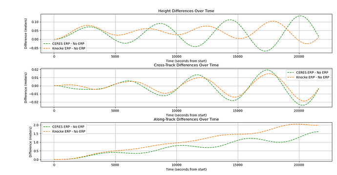
I took a starlink TLE as initial conditions and propagated for 6 hours
- Once with just 10,10 gravity field
- Once with 10,10 gravity field and
KnockeRediffusedForceModel
- Once with 10,10 gravity field and the method below.
both methods are quite similar.
I would love to hear if anyone had any suggestions for improvements.
Thanks again for your help @Vincent !!
import orekit
from orekit.pyhelpers import setup_orekit_curdir, absolutedate_to_datetime
orekit.pyhelpers.download_orekit_data_curdir()
vm = orekit.initVM()
setup_orekit_curdir()
from org.orekit.utils import Constants, PVCoordinates, IERSConventions
from org.orekit.forces import PythonForceModel
from org.orekit.frames import FramesFactory
from org.orekit.bodies import OneAxisEllipsoid
from org.hipparchus.geometry.euclidean.threed import Vector3D
from orekit import JArray_double
from java.util import Collections
from java.util.stream import Stream


from tools.utilities import find_nearest_index, lla_to_ecef, julian_day_to_ceres_time
from tools.data_processing import calculate_satellite_fov, is_within_fov_vectorized, sat_normal_surface_angle_vectorized
import numpy as np

def compute_erp_at_sc(ceres_time_index, radiation_data, sat_lat, sat_lon, sat_alt, horizon_dist):
    # Earth radius in meters
    R = Constants.WGS84_EARTH_EQUATORIAL_RADIUS
    # Latitude and longitude arrays
    lat = np.arange(-89.5, 90.5, 1)  # 1-degree step from -89.5 to 89.5
    lon = np.arange(-179.5, 180.5, 1)  # 1-degree step from -179.5 to 179.5

    # Mesh grid creation
    lon2d, lat2d = np.meshgrid(lon, lat)

    # FOV calculations
    fov_mask = is_within_fov_vectorized(sat_lat, sat_lon, horizon_dist, lat2d, lon2d)
    radiation_data_fov = np.ma.masked_where(~fov_mask, radiation_data[ceres_time_index, :, :])
    cos_thetas = sat_normal_surface_angle_vectorized(sat_alt, sat_lat, sat_lon, lat2d[fov_mask], lon2d[fov_mask])
    cosine_factors_2d = np.zeros_like(radiation_data_fov)
    cosine_factors_2d[fov_mask] = cos_thetas

    # Adjusting radiation data
    adjusted_radiation_data = radiation_data_fov * cosine_factors_2d

    # Satellite position and distance calculations
    sat_ecef = np.array(lla_to_ecef(sat_lat, sat_lon, sat_alt))
    ecef_x, ecef_y, ecef_z = lla_to_ecef(lat2d, lon2d, np.zeros_like(lat2d))
    ecef_pixels = np.stack((ecef_x, ecef_y, ecef_z), axis=-1)
    vector_diff = sat_ecef.reshape((1, 1, 3)) - ecef_pixels
    distances = np.linalg.norm(vector_diff, axis=2) * 1000  # Convert to meters

    # Radiation calculation
    delta_lat = np.abs(lat[1] - lat[0])
    delta_lon = np.abs(lon[1] - lon[0])
    area_pixel = R**2 * np.radians(delta_lat) * np.radians(delta_lon) * np.cos(np.radians(lat2d))  # Convert to m^2
    P_rad = adjusted_radiation_data * area_pixel / (np.pi * distances**2) # map of power flux in W/m^2 for each pixel

    #need to convert the vector_diff to eci frame
    unit_vectors = vector_diff / distances[..., np.newaxis] * 1000 # Convert to unit vectors in meters
    radiation_force_vectors = unit_vectors * P_rad[..., np.newaxis] / (299792458)  # Convert to Newtons
    # Summing all force vectors
    total_radiation_force_vector = np.sum(radiation_force_vectors[fov_mask], axis=0)
    # Satellite area in square meters
    satellite_area = 10.0

    # Total force due to radiation pressure (not including reflection for now)
    total_force = total_radiation_force_vector * satellite_area

    # Satellite mass in kilograms
    satellite_mass = 500.0

    # Calculate acceleration
    acceleration_vector = total_force / satellite_mass

    scalar_acc = np.linalg.norm(acceleration_vector)
    print(f"scalar_acc:{scalar_acc}m/s^2")

    down_vector = - sat_ecef / np.linalg.norm(sat_ecef)  # Normalize the satellite's position vector to get the down vector
    total_radiation_vector_normalized = total_radiation_force_vector / np.linalg.norm(total_radiation_force_vector)  # Normalize the total radiation vector

    cos_theta = np.dot(total_radiation_vector_normalized, down_vector)  # Cosine of the angle
    angle_radians = np.arccos(cos_theta)  # Angle in radians
    angle_degrees = np.rad2deg(angle_radians)  # Convert to degrees

    return np.array(acceleration_vector), scalar_acc, angle_degrees

class CERES_ERP_ForceModel(PythonForceModel):
    def __init__(self, ceres_times, combined_radiation_data):
        super().__init__()
        self.scalar_acc_data = []
        self.erp_angle_data = []
        self.time_data = []
        self.ceres_times = ceres_times
        self.combined_radiation_data = combined_radiation_data

    def acceleration(self, spacecraftState, doubleArray):
        # Compute the current altitude within the acceleration method
        pos = spacecraftState.getPVCoordinates().getPosition()
        alt_m = pos.getNorm() - Constants.WGS84_EARTH_EQUATORIAL_RADIUS
        alt_km = alt_m / 1000.0
        horizon_dist = calculate_satellite_fov(alt_km)
        # Get the AbsoluteDate
        absolute_date = spacecraftState.getDate()
        # Convert AbsoluteDate to Python datetime
        date_time = absolutedate_to_datetime(absolute_date)
        # convert date_time to julianday
        jd_time = date_time.toordinal() + 1721425.5 + date_time.hour / 24 + date_time.minute / (24 * 60) + date_time.second / (24 * 60 * 60)
        # Get the ECI and ECEF frames
        ecef = FramesFactory.getITRF(IERSConventions.IERS_2010, True)
        # Transform the position vector to the ECEF frame
        pv_ecef = spacecraftState.getPVCoordinates(ecef).getPosition()
        # Define the Earth model
        earth = OneAxisEllipsoid(
            Constants.WGS84_EARTH_EQUATORIAL_RADIUS,
            Constants.WGS84_EARTH_FLATTENING,
            ecef)
        # Convert ECEF coordinates to geodetic latitude, longitude, and altitude
        geo_point = earth.transform(pv_ecef, ecef, spacecraftState.getDate())
        # Extract latitude and longitude in radians
        latitude = geo_point.getLatitude()
        longitude = geo_point.getLongitude()
        # Convert radians to degrees if needed
        latitude_deg = np.rad2deg(latitude)
        longitude_deg = np.rad2deg(longitude)
        ceres_time = julian_day_to_ceres_time(jd_time)
        ceres_indices = find_nearest_index(self.ceres_times, ceres_time)
        erp_vec, scalar_acc, erp_angle = compute_erp_at_sc(ceres_indices, self.combined_radiation_data, latitude_deg, longitude_deg, alt_km, horizon_dist)
        # convert the erp_vec to ECI
        eci = FramesFactory.getEME2000()
        # Transform the position vector to the ECI frame
        transform = ecef.getTransformTo(eci, spacecraftState.getDate())
        erp_vec_ecef_pv = PVCoordinates(Vector3D(float(erp_vec[0]), float(erp_vec[1]), float(erp_vec[2])))
        # Transform the ERP vector to ECI frame
        erp_vec_eci_pv = transform.transformPVCoordinates(erp_vec_ecef_pv)
        # Extract the transformed vector components
        erp_vec_eci = erp_vec_eci_pv.getPosition()
        # Store the scalar acceleration and other data
        self.scalar_acc_data.append(scalar_acc)
        self.erp_angle_data.append(erp_angle)
        self.time_data.append(jd_time)
        # Create the Orekit vector for the ERP force in ECI frame
        orekit_erp_vec = Vector3D(erp_vec_eci.getX(), erp_vec_eci.getY(), erp_vec_eci.getZ())
        # print("orekit_erp_vec components:", orekit_erp_vec.getX(), orekit_erp_vec.getY(), orekit_erp_vec.getZ())
        return orekit_erp_vec

    def addContribution(self, spacecraftState, timeDerivativesEquations):
        timeDerivativesEquations.addNonKeplerianAcceleration(self.acceleration(spacecraftState, None))

    def getParametersDrivers(self):
        return Collections.emptyList()

    def init(self, spacecraftState, absoluteDate):
        pass

    def getEventDetectors(self):
        return Stream.empty()
