Hello everyone,
I noticed something weird. I’m trying to construct an orbit starting from position and velocity vectors reported in a CDM. However, I noticed that the orbit I obtain doesn’t match with the one reported in the CDM. For example, the perigee/apogee altitudes I obtain are like 15-20 km off.
The data in the CDM is the following:
EPHEMERIS_NAME =NONE
COVARIANCE_METHOD =CALCULATED
MANEUVERABLE =N/A
REF_FRAME =ITRF
GRAVITY_MODEL =EGM-96: 36D 36O
ATMOSPHERIC_MODEL =JBH09
N_BODY_PERTURBATIONS =MOON,SUN
SOLAR_RAD_PRESSURE =YES
EARTH_TIDES =YES
INTRACK_THRUST =NO
COMMENT Covariance Scale Factor = 1.000000
COMMENT Exclusion Volume Radius = 5.000000 [m]
TIME_LASTOB_START =2022-06-14T17:25:22.284000
TIME_LASTOB_END =2022-06-15T17:25:22.284000
RECOMMENDED_OD_SPAN =3.61 [d]
ACTUAL_OD_SPAN =3.61 [d]
OBS_AVAILABLE =77
OBS_USED =77
RESIDUALS_ACCEPTED =100 [%]
WEIGHTED_RMS =1.046
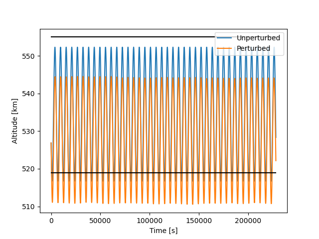
COMMENT Apogee Altitude = 555 [km]
COMMENT Perigee Altitude = 519 [km]
COMMENT Inclination = 64.6 [deg]
AREA_PC =4.0115 [m**2]
CD_AREA_OVER_MASS =0.058686041758 [m**2/kg]
CR_AREA_OVER_MASS =0.03235206892 [m**2/kg]
THRUST_ACCELERATION =0 [m/s**2]
SEDR =0.0035275 [W/kg]
X =-4518.633435 [km]
Y =-5197.753381 [km]
Z =311.492934 [km]
X_DOT =1.898538049 [km/s]
Y_DOT =-2.038217158 [km/s]
Z_DOT =-6.861948694 [km/s]
COMMENT DCP Density Forecast Uncertainty = 2.558565910000000E-01
COMMENT DCP Sensitivity Vector RTN Pos = -1.254193830493978E+02 1.423044570895714E+04 -1.040300442687621E+01 [m]
COMMENT DCP Sensitivity Vector RTN Vel = -1.571039504748616E+01 2.408689885152749E-02 1.185898604331550E-03 [m/sec]
CR_R =1246.284324476203 [m**2]
CT_R =-121414.6354471415 [m**2]
CT_T =13852195.53971295 [m**2]
CN_R =12.69778964200831 [m**2]
CN_T =-9588.113401542814 [m**2]
CN_N =212.8639702159042 [m**2]
CRDOT_R =134.0091247376327 [m**2/s]
CRDOT_T =-15292.31649573428 [m**2/s]
CRDOT_N =10.60632150301289 [m**2/s]
CRDOT_RDOT =16.88245367896203 [m**2/s**2]
CTDOT_R =-0.4072702057806717 [m**2/s]
CTDOT_T =23.56698671492368 [m**2/s]
CTDOT_N =0.06416078696427642 [m**2/s]
CTDOT_RDOT =-0.02598128978827344 [m**2/s**2]
CTDOT_TDOT =0.0002636059025557587 [m**2/s**2]
CNDOT_R =-0.09248500369794832 [m**2/s]
CNDOT_T =1.080203506875406 [m**2/s]
CNDOT_N =-0.1932606908970702 [m**2/s]
CNDOT_RDOT =-0.001223627159008689 [m**2/s**2]
CNDOT_TDOT =0.00009394189797188796 [m**2/s**2]
CNDOT_NDOT =0.0004704721269538941 [m**2/s**2]
CDRG_R =0 [m**3/kg]
CDRG_T =0 [m**3/kg]
CDRG_N =0 [m**3/kg]
CDRG_RDOT =0 [m**3/(kg*s)]
CDRG_TDOT =0 [m**3/(kg*s)]
CDRG_NDOT =0 [m**3/(kg*s)]
CDRG_DRG =0 [m**4/kg**2]
CSRP_R =0 [m**3/kg]
CSRP_T =0 [m**3/kg]
CSRP_N =0 [m**3/kg]
CSRP_RDOT =0 [m**3/(kg*s)]
CSRP_TDOT =0 [m**3/(kg*s)]
CSRP_NDOT =0 [m**3/(kg*s)]
CSRP_DRG =0 [m**4/kg**2]
CSRP_SRP =0 [m**4/kg**2]
The first thing I do in my code is rotate the vectors into EME2000 as:
itrf2eme = FramesFactory.getITRF(IERSConventions.IERS_2010, True).getTransformTo(FramesFactory.getEME2000(), someDate);
r1v1 = itrf2eme.transformPVCoordinates(PVCoordinates(r1, v1));
Then I use this rotated vectors as input to build the orbit as:
orbitSat = KeplerianOrbit(r1v1, FramesFactory.getEME2000(), someDate, Constants.WGS84_EARTH_MU);
However, if I compute the perigee altitude as:
orbitSat.getA()*(1 - orbitSat.getE()) - Constants.WGS84_EARTH_EQUATORIAL_RADIUS
The value I get is around 506 km while the CDM reports a value of 519 km. And even I use the Earth mean radius, the value doesn’t match either. The inclination is wrong too:
orbitSat.getI()*180/np.pi
returns a value of 64.44 deg, while the CDM reports an inclination of 64.6 deg.
Does anyone have any suggestion?