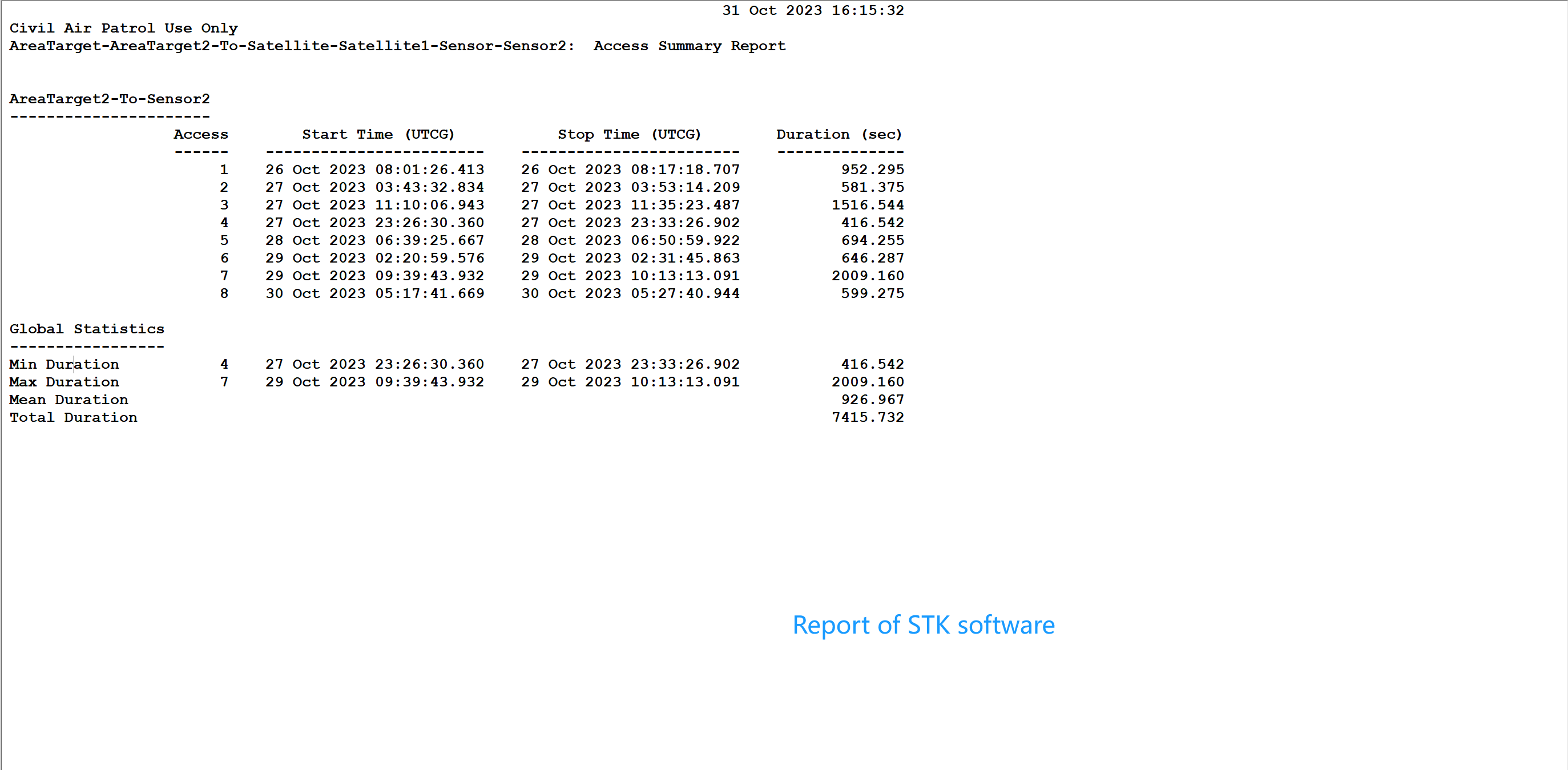
I will show you the types of satellites and ground stations I have defined in STK, as well as the report results output by STK.
At the same time, I will display the results of running the orekit code, and may I ask why there are differences. If it’s convenient for you, please help me modify the specific code so that I can have a clear understanding of the entire usage process. Thank you!

source code:
import java.io.File;
import java.util.Locale;
import org.hipparchus.geometry.euclidean.threed.Vector3D;
import org.hipparchus.geometry.spherical.twod.SphericalPolygonsSet;
import org.hipparchus.ode.events.Action;
import org.hipparchus.util.FastMath;
import org.orekit.bodies.BodyShape;
import org.orekit.bodies.GeodeticPoint;
import org.orekit.bodies.OneAxisEllipsoid;
import org.orekit.data.DataContext;
import org.orekit.data.DataProvidersManager;
import org.orekit.data.DirectoryCrawler;
import org.orekit.errors.OrekitException;
import org.orekit.frames.Frame;
import org.orekit.frames.FramesFactory;
import org.orekit.models.earth.tessellation.EllipsoidTessellator;
import org.orekit.orbits.KeplerianOrbit;
import org.orekit.orbits.Orbit;
import org.orekit.propagation.Propagator;
import org.orekit.propagation.SpacecraftState;
import org.orekit.propagation.analytical.KeplerianPropagator;
import org.orekit.propagation.events.GeographicZoneDetector;
import org.orekit.time.AbsoluteDate;
import org.orekit.time.TimeScalesFactory;
import org.orekit.utils.Constants;
import org.orekit.utils.IERSConventions;
import org.orekit.utils.PVCoordinates;
/** Orekit tutorial for special event detection.
-
This tutorial shows how to easily check for visibility between a satellite and a ground station.
-
@author Pascal Parraud
*/
public class RectangularRegionOnEarth {/** Private constructor for utility class. */
private RectangularRegionOnEarth() {
// empty
}/** Program entry point.
-
@param args program arguments (unused here)
*/
public static void main(final String args) {
try {
// configure Orekit
final File home = new File(System.getProperty(“user.home”));
final File orekitData = new File(home, “orekit-data”);
if (!orekitData.exists()) {
System.err.format(Locale.US, “Failed to find %s folder%n”,
orekitData.getAbsolutePath());
System.err.format(Locale.US, “You need to download %s from %s, unzip it in %s and rename it ‘orekit-data’ for this tutorial to work%n”,
“orekit-data-master.zip”, “https://gitlab.orekit.org/orekit/orekit-data/-/archive/master/orekit-data-master.zip”,
home.getAbsolutePath());
System.exit(1);
}
final DataProvidersManager manager = DataContext.getDefault().getDataProvidersManager();
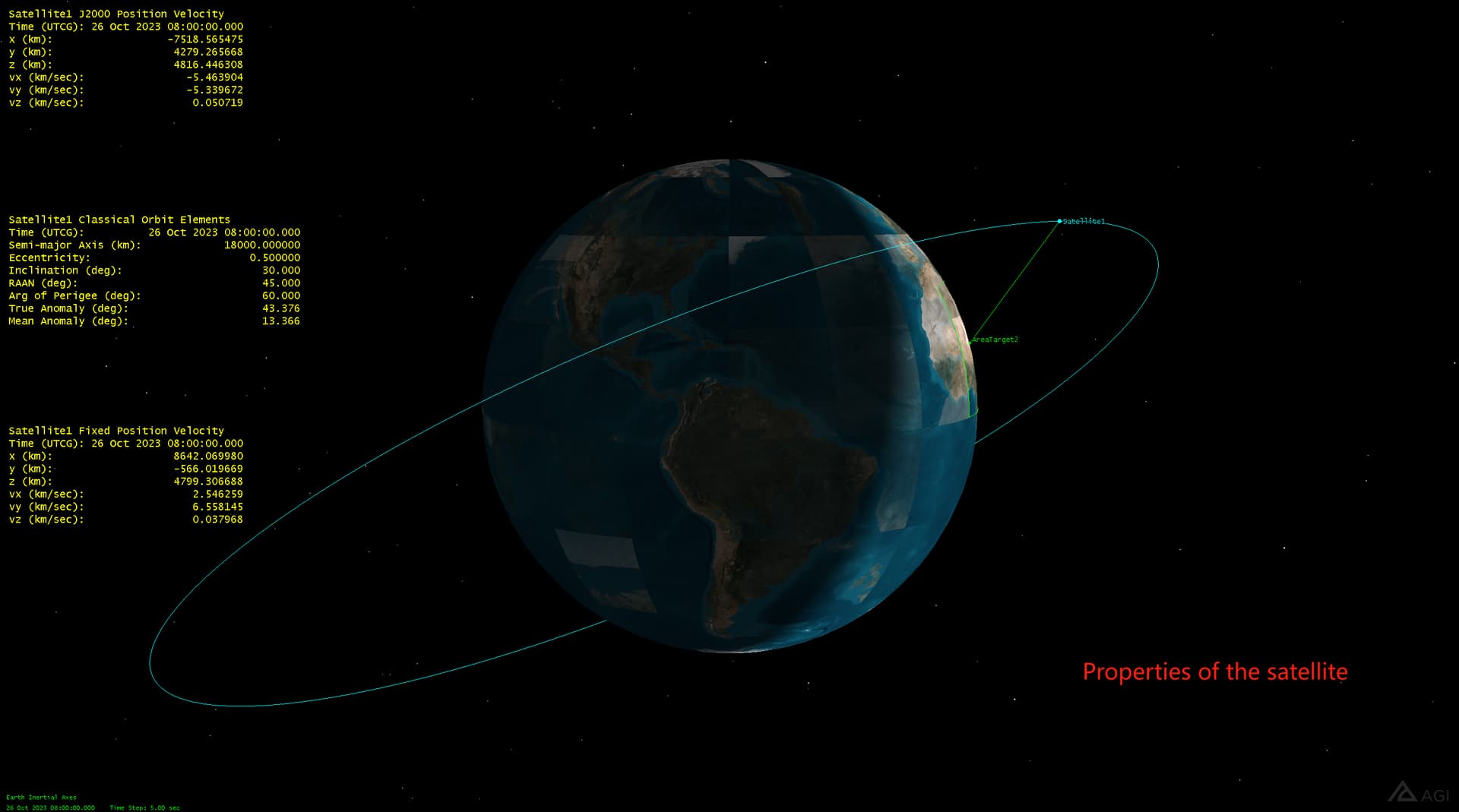
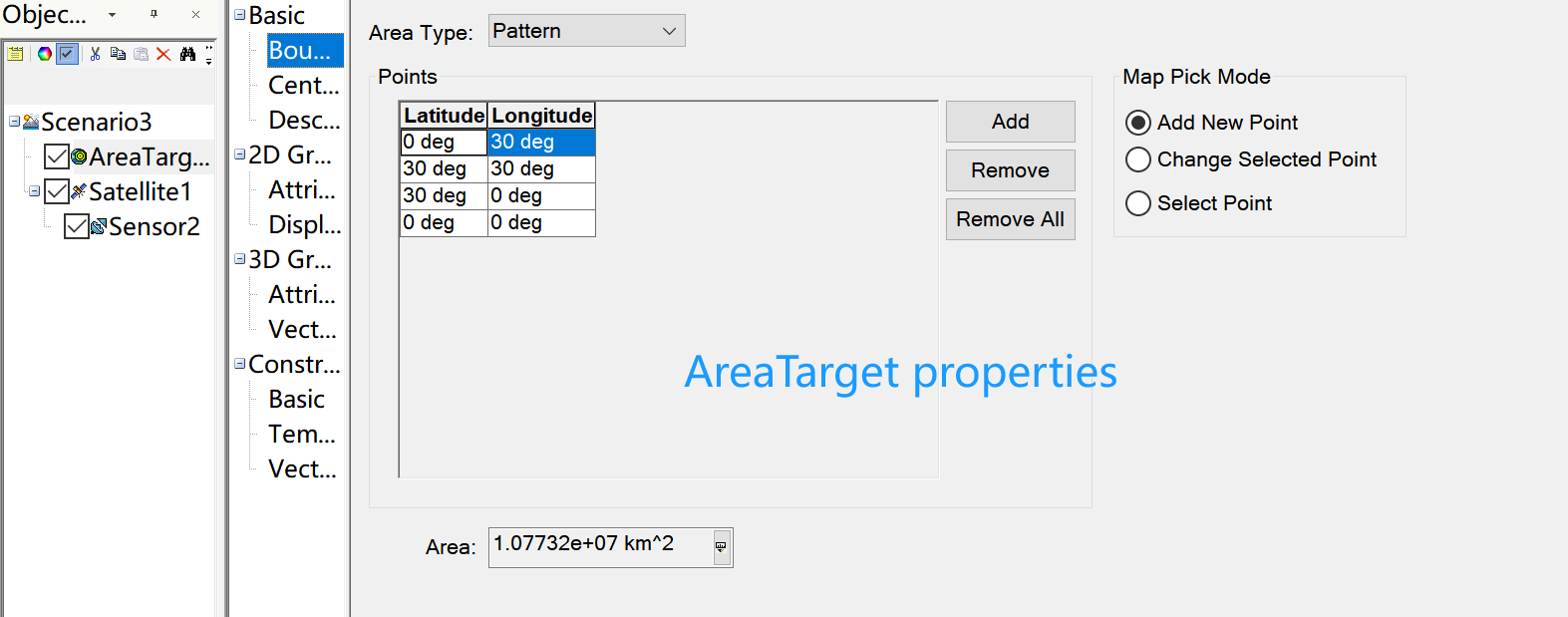
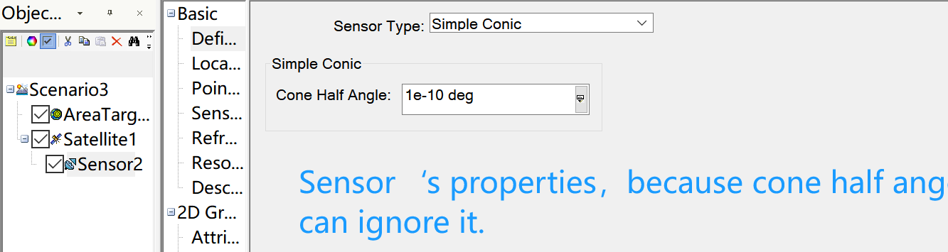
manager.addProvider(new DirectoryCrawler(orekitData));// Initial state definition : date, orbit final AbsoluteDate initialDate = new AbsoluteDate(2023, 10, 26, 8, 00, 00.000, TimeScalesFactory.getUTC()); final double mu = 3.986004415e+14; // gravitation coefficient final Frame inertialFrame = FramesFactory.getEME2000(); // inertial frame for orbit definition final Vector3D position = new Vector3D(-7518565.475, 4279265.668, 4816446.308); final Vector3D velocity = new Vector3D(-5463.904, -5533.9672, 50.719); final PVCoordinates pvCoordinates = new PVCoordinates(position, velocity); final Orbit initialOrbit = new KeplerianOrbit(pvCoordinates, inertialFrame, initialDate, mu); // Propagator : consider a simple Keplerian motion final Propagator kepler = new KeplerianPropagator(initialOrbit); // Earth and frame final Frame earthFrame = FramesFactory.getITRF(IERSConventions.IERS_2010, true); final BodyShape earth = new OneAxisEllipsoid(Constants.WGS84_EARTH_EQUATORIAL_RADIUS, Constants.WGS84_EARTH_FLATTENING, earthFrame); //创建一个地面区域 GeodeticPoint point1 = new GeodeticPoint(Math.toRadians(0), Math.toRadians(30), 0.0); GeodeticPoint point2 = new GeodeticPoint(Math.toRadians(30), Math.toRadians(30), 0.0); GeodeticPoint point3 = new GeodeticPoint(Math.toRadians(30), Math.toRadians(0), 0.0); GeodeticPoint point4 = new GeodeticPoint(Math.toRadians(0), Math.toRadians(0), 0.0); // 创建表示地面区域的SphericalPolygonsSet SphericalPolygonsSet region = EllipsoidTessellator.buildSimpleZone(1.0e-10, point1, point2, point3, point4); // Event definition final double maxcheck = 60; final double threshold = 0.001; final double elevation = FastMath.toRadians(0.0); final GeographicZoneDetector zoneDetector = new GeographicZoneDetector(maxcheck, threshold, earth, region, elevation) .withHandler((s, detector, increasing) -> { if (increasing) { System.out.println("Visibility begins at " + s.getDate()); } else { System.out.println("Visibility ends at " + s.getDate()); System.out.println(); } return Action.CONTINUE; // Continue processing the event }); // Add event to be detected kepler.addEventDetector(zoneDetector); // Propagate from the initial date to the first raising or for the fixed duration final SpacecraftState finalState = kepler.propagate(initialDate.shiftedBy(360000.)); System.out.println(" Final state : " + finalState.getDate().durationFrom(initialDate));} catch (OrekitException oe) {
System.err.println(oe.getLocalizedMessage());
}
}
-
}